East Bristol Liveable Neighbourhood Survey
We asked
We asked people who live, work and travel through Barton Hill, Redfield and St George to share their views on the East Bristol Liveable Neighbourhood (EBLN) trial.
The trial, which began in April 2025, introduced a range of transport measures designed to reduce traffic, improve air quality, and make streets safer and more pleasant for walking, wheeling and cycling. We asked for feedback to help evaluate the scheme and decide its future.
The survey asked people about their travel habits, what's important about where they live, and how they experience their local area and more.
The questions were matched to those asked through the 2022 ‘co-discover' survey, so the answers could be compared with perceptions of the area before the EBLN trial was designed.
You said
In total 2,746 people filled in the EBLN survey. The results are summarised in the Engagement Report:
EBLN Engagement Report 2025 (pdf, 1.83 MB)
- EBLN Engagement Report 2025 Appendix A - Perception survey full details (pdf, 4.39 MB)
- EBLN Engagement Report 2025 Appendix B - Full Polling Report (pdf, 3.92 MB)
- EBLN Engagement Report 2025 Appendix C - WECIL audit recommendations (pdf, 103 KB)
- EBLN Engagement Report 2025 Appendix D - Citizens' Observatory Report (pdf, 135 KB)
- EBLN Engagement Report 2025 Appendix E - Poster locations and letter examples (pdf, 418 KB)
- EBLN Engagement Report 2025 Appendix F - Perception survey letter to residents (pdf, 200 KB)
- EBLN Engagement Report 2025 Appendix G - Active travel offers and bus gate exemptions further info (pdf, 292 KB)
We did
An pdf EBLN Monitoring Report 2025(14.81 MB) was published alongside the Engagement Report in December 2025. The monitoring report compares data, such as traffic volumes, collected in October 2025 with data from October 2024.
This data, the responses to the survey and polling, along with feedback received throughout the trial, including over 500 emails, was used to inform changes to the scheme.
Based on the information and feedback, we announced plans for a series of changes to make the Liveable Neighbourhood more accessible for residents, businesses and the emergency services. These included:
Proposals include:
- Moving the bus gate on Avonvale Road to the east of its junction with Mildred Street, to allow a left turn from Marsh Lane onto Avonvale Road, improving vehicle access to the Wellspring Centre and Days Road. There will still be a bus gate across Avonvale Road, preventing access from Marsh Lane turning right onto Avonvale Road and in reverse.
- Removing the bus gate on Marsh Lane (between Glendare Rd and Barton Court), to improve access between Feeder Road, Barton Hill and St Phillip's Causeway and support businesses in the area.
- Removing the planters on Victoria Avenue West (between where it meets Byron Street and Morse Road), to improve access within the surrounding residential streets, including for waste crews.
- Replacing the bollards on The Avenue and Ducie Road bridge with camera enforcement, to make it quicker for emergency services to access properties across the area and to enable drivers with EBLN bus gate exemptions, such as taxi drivers and blue badge holders, to use these routes.
These proposals were subject to a statutory Traffic Regulation Orders (TROs) consultation in March 2026 and were subsequently approved.
Further information
Bristol's strong, engaged, and diverse communities are what make the city an attractive place to live, work and study.
While all of Bristol's neighbourhoods are places of pride for the communities they serve, we know there is more that can be done to make sure they better meet the needs of our residents as well as the challenges we face as a city both now and in the future.
What is a Liveable Neighbourhood?
A Liveable Neighbourhood is an area of a city that is more people-centred and 'liveable'.
Liveable Neighbourhood schemes aim to create safe, healthy, inclusive, and attractive places where everyone can breathe clean air, have access to green spaces, and feel a part of a community.
As well as prioritising community wellbeing over through-traffic, these schemes set out to encourage sustainable travel by making it easier to walk, wheel (such as using a wheelchair or mobility scooter), cycle or use public transport.
The status of East Bristol Liveable Neighbourhood pilot
East Bristol is the first Liveable Neighbourhood scheme to be trialled in Bristol.
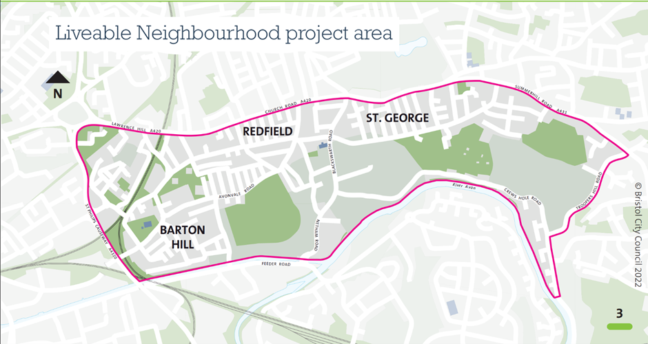
The trial area, which includes Barton Hill and parts of Redfield and of St George, south of Church Road, is outlined on the map below:
Now that the trial scheme has been in place for some time, we are assessing it to decide whether it should be made permanent.
Analysing traffic and other data, auditing layouts from an accessibility perspective, and gauging people's views are some of the ways we are assessing the scheme.
We now want to know how you feel about your local area following the changes.
Community engagement programme
- Co-discover: January to July 2022. Understanding what people love and what they would change in their neighbourhood. Mapping the barriers to a more liveable neighbourhood.
- Co-develop: September 2022 to March 2023. Gathering detailed community aspirations using a design toolkit to help shape the Liveable Neighbourhood.
- Trial scheme information sharing: May to June 2023. Sharing the plan, including a map, for the Liveable Neighbourhood trial that was developed with the community.
- Trial scheme statutory consultation: January to February 2024. This is the formal process for creating Traffic Regulation Orders to make changes to the highway.
If the decision is made to make the scheme permanent, there will be statutory consultation on specific (Traffic Regulation Order-dependent) elements of the scheme (e.g. any changes to modal filters, parking or double yellow lines) in 2026.
We would also aim to carry out further targeted community engagement on proposals for some specific public spaces, in order to inform final layouts.
A second programme of street art and cultural activities might also follow construction of the permanent scheme, which would involve further engagement with communities across the area.
Key dates
- Start date: 29 September 2025
- End date: 7 November 2025