
Bristol city centre transport changes 2024 consultation
Bristol city centre is set to change in the coming years, with major new housing developments and leisure and retail facilities planned. This will help the city tackle its housing crisis and sustain the vitality of the central area.
To prepare for around 5,000 more people living in and travelling around Broadmead, we're proposing changes to transform some of our public spaces and surrounding roads to make the city centre more welcoming and people-friendly.
These changes would improve walking, wheeling and cycling routes, benefit existing bus services, and support our long-term goal to create a segregated rapid transit route from the southwest to the northeast of the city.
We are at the early stage of designing the plans and need your views to make sure we get it right.
Overview of the plans
In this consultation, we are proposing changes in five areas:
- Broadmead
- Bedminster Bridges
- Redcliffe Roundabout
- Temple Way
- Bond Street
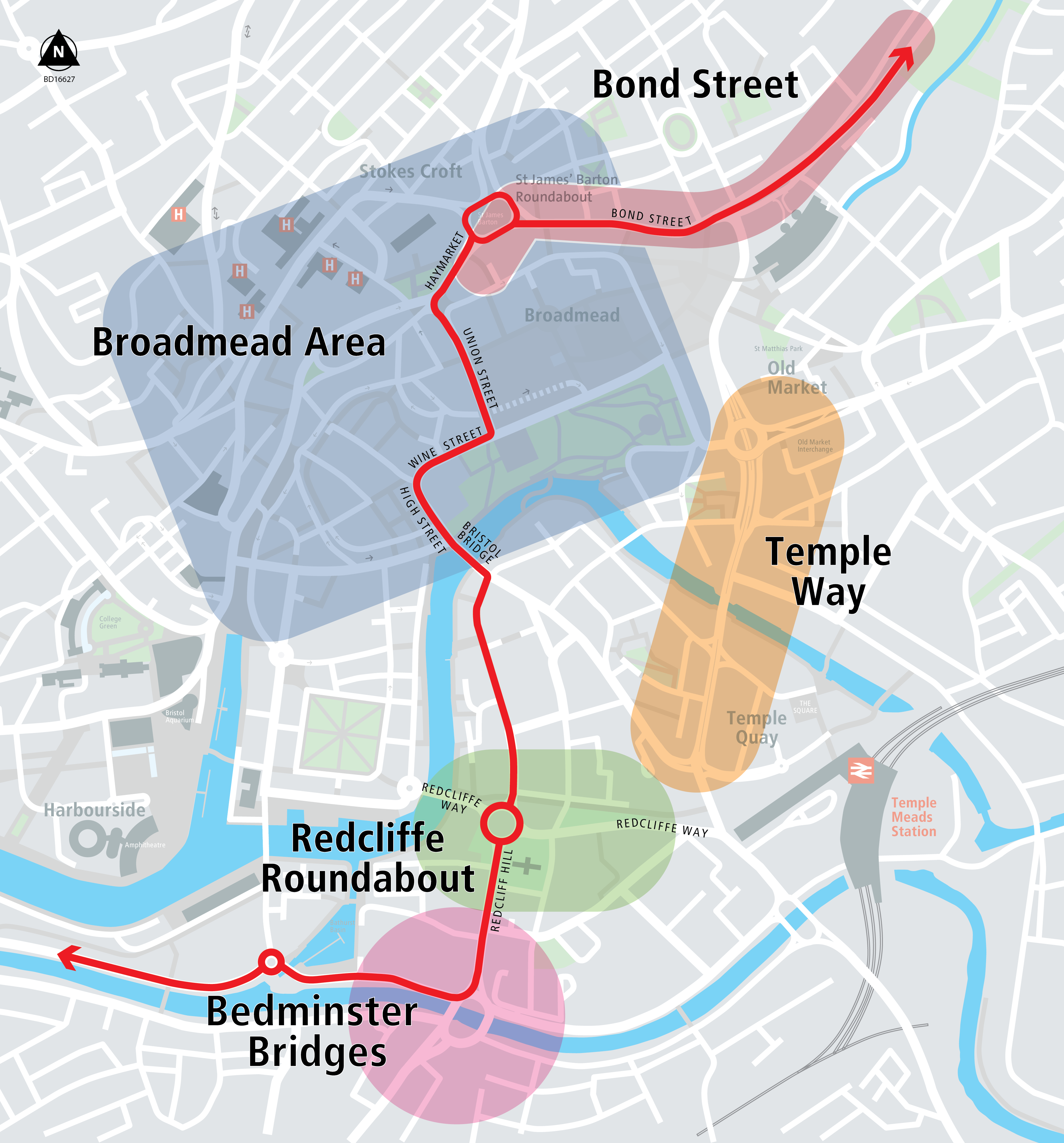
Across these five areas, the proposals include changes to public spaces in the Broadmead area, changes to bus routes and bus infrastructure, and proposals to make walking, wheeling and cycling safer and easier
Proposals to change public spaces in the Broadmead include:
- pedestrianising The Horsefair and Penn Street, with access for emergency vehicles, and deliveries for businesses allowed at set times when the streets are less busy
- removing most of the traffic from Union Street
- introducing more landscaping, seating and art space
Proposals to bus routes and bus infrastructure include:
- changes to road layouts that will make it possible to operate a rapid transit route running in both directions through Union Street and The Haymarket
- changing the routes some buses take through the city centre to avoid the pedestrianised streets
- removing buses that have terminated and stand empty for long periods of time from pedestrian and shopping areas
- adding bus priority measures, including bus gates and bus lanes across the five areas
- moving bus stop locations
Proposals to make walking, wheeling and cycling safer and easier across all five areas, including:
- creating more than 3.5km of new segregated cycle routes and joining up gaps in the cycle network
- pedestrianising streets, reducing traffic and changing road layouts
- widening pavements
- upgrading road crossings
The reasons why these proposed changes are needed are described in the further information section below.
For more background, detail and artist’s impressions and 3D designs of how the changes could look, visit Bristol City Centre Transport Changes project page on the West website.
The Bristol city centre transport changes programme is being funded by the government as part of the City Region Sustainable Transport Settlement, which is administered by the West of England Combined Authority.
Consultation report
This consultation is the first step in a three-year project to transform Bristol city centre. We have analysed the responses to the survey.
pdf Bristol City Centre Transport Changes Consultation Report(2.75 MB)
This will inform how the plans for the project are progressed and what changes are needed.
Further information
Reasons for the proposed city centre transport changes
Bristol is a growing city with more people needing to travel into and through the city centre. Our roads are already at capacity with high levels of air pollution and congestion.
Bristol City Centre Development and Delivery Plan sets out a vision for the regeneration of the city centre, mainly focusing on Broadmead and Castle Park. It plans for:
- 2,500 more homes
- new student and co-living accommodation
- offices, shops and leisure facilities
Our vision for the Broadmead area is to create:
- an inclusive, sustainable and re-connected place for everybody
- a place of diverse retail with vibrant cultural facilities and a thriving evening economy
- somewhere to call home
With more people in the city centre, we need to:
- make space for them
- improve streets, public transport and active travel
- tackle air pollution and carbon emissions
The changes we're proposing would enable people to switch from car journeys to more sustainable public transport and active travel options (walking, wheeling and cycling). This in turn will help us to work towards net zero while giving people all the health and wellbeing benefits of more physical activity.
We're not asking for feedback on the Bristol City Centre Development and Delivery Plan because we've already consulted on that and adopted it. In this consultation, we're asking for your views on the transport proposals needed to support the plan.
Scheme wide or rapid transit route
Tree removal and landscaping
Some trees would be removed as part of the Broadmead area, Bond Street and Bedminster Bridges proposals. The proposals include planting more trees than we'll remove, exceeding the Bristol Tree Replacement Standard.
In the Broadmead area the proposals include creating a large amount of new public space that could be used for rain gardens, trees, seating and public art (about 10 tennis courts' worth of space). We would follow the design principles and greening and art strategy set out in the Bristol City Centre Development and Delivery Plan when we design these elements.
Impact on existing bus services
Existing bus services will benefit from the new bus priority measures in all 5 areas. Services will become more reliable by separating out buses from general traffic.
Why a new rapid transit service is needed
We're always looking to enhance and increase the options available to people, creating new, fast routes that link up communities from across the city.
Removal of parking spaces
Some parking spaces would be removed as part of these proposals. There will not be a reduction in blue badge or residential parking. For more detail, see the answers in the geographic areas that relate to parking spaces.
Taxi access to the bus gates and lanes
- Taxis can use the new bus lanes on Bond Street, Newfoundland Way and Newfoundland Circus.
- Taxis will not be able to use the new bus lanes on Union Street. This is like the current arrangement on Broad Quay. It ensures that the new road layout will be able to operate two-way for high frequency, high reliability, low noise and low pollution buses. We estimate that there'll be a bus every 5 minutes in each direction.
- We're still deciding whether taxis should use the bus only bridge and bus lanes which access Bedminster Bridge. We're doing traffic modelling to understand how many taxis would use this facility and the impact on bus journey times. We also want to hear your views through this consultation. Whether or not to allow taxis through the bus gates will be included in the Traffic Regulation Order consultation.
When the work will start
The funding for this project needs to be spent by spring 2027, so construction work could start soon.
We want to deliver benefits as soon as possible. However, we're aware of the many and varied construction works planned in the city in the next few years. These include:
- expanding the Heat Network
- many private developments
- refurbishing the New Cut bridges and river wall structures
- transforming Bristol Temple Meads station
We don't want construction of all these projects near each other happening at similar times. To reduce the impact, we're working on a phasing plan to determine the order projects should happe in. This may involve doing some parts of schemes earlier than others, and it may require temporary changes to the way roads work so we can close roads for development works, especially around The Galleries in Broadmead.
Bedminster Bridges
Changing from a roundabout
The current layout does not provide an efficient route for all modes of transport. Changing it would allow us to significantly improve how buses, cycles and pedestrians travel through this area.
Limiting access to York Road, Clarence Road and Redcliff Hill
All the proposed changes are integral to making the new junction work. We've carried out traffic modelling to ensure that traffic can still flow through the junction, and this has informed which turns are and are not permitted in the proposals. We want to hear your feedback on the turns which are and are not permitted as part of this consultation.
Making Guinea Street one way
This means there'll be no traffic turning out of Guinea Street crossing a bus lane and in front of a bus stop, which would be a safety hazard. It also allows Guinea Street to be narrower, which will make crossing this street easier for pedestrians and cyclists.
Tree removal
A small number of trees would need to be removed to make way for the new layout. We would plant even more trees to replace them, resulting in an increase in the total number of trees in the area.
Redcliffe Roundabout
The new rapid transit route would use the bus gates on Redcliffe Street.
General traffic would still be able to access and drive through the area, but the bus gate on Redcliffe Street would change the routes used. General traffic would be able to enter and exit the area via St Thomas Street and Phippen Street. The junction between Phippen Street and Redclffe Way would be changed to allow traffic to turn right out of Phippen Street.
Access to private car parks on Redcliffe Street
The bus gate on Redcliffe Street has been located so that private car parks could still be accessed from Victoria Street. There would be sufficient space to allow vehicles to turn around without entering the bus gate.
Why we don't want to change the roundabout to a junction
There are many trees within the roundabout and it's our policy not to remove any trees unnecessarily.
There are also lots of underground utilities in the roundabout. If we changed the road layout from a roundabout to something else we'd need to relocate these services which would cost around £3 million. We'd rather spend that money above ground where people can see and feel the benefits.
The roundabout offers a U-turn facility which is used by many vehicles travelling from the south east of the city (from Brislington and St Annes) to the train station. Vehicles can’t turn right into the train station from the A4 so they use the roundabout to turn around. We want to keep this facility.
With this design, road space has been re-allocated to walking, cycling and public transport, with protected cycle lanes on all arms of the roundabout, as well as bus priority measures and upgraded pedestrian crossings.
General traffic lanes would be retained so the area and destinations, such as Temple Meads, could still be accessed by private car.
Tree removal
The proposed changes to kerb lines avoid street trees wherever possible and detailed designs will take account of root protection to ensure trees are not damaged. Our proposals do not include removing any street trees as part of the Redcliffe Roundabout works. Additional planting and soft landscaping will be introduced at the Redcliffe Street bus gate and the area next to Freshford House.
Portwall Lane car park
The Local Plan designates this site as housing but no changes are proposed to this car park as part of this scheme.
Lack of cycle tracks on Redcliffe Street
The introduction of bus gates on Redcliffe Street would help prioritise buses and provide a direct route to the city centre. General traffic can still access the area via St Thomas and Phippen Street but it's likely to reduce in volume on Redcliffe Street itself. Reducing the volume and speed of traffic on Redcliffe Street will help make the environment attractive for people cycling of all ages and abilities, meaning cycle tracks aren’t needed. This is in line with national guidance on cycle design (LTN1/20).
How the scheme improves accessibility and removes conflict between different modes of transport
Our proposals include introducing segregated cycle ways to provide direct, coherent, and safe routes linking people to the city centre, Temple Meads, Bedminster Bridges and south Bristol.
This would separate pedestrians and cyclists, removing the existing shared space. Shared space often creates conflict because people walk and cycle at different speeds. Shared space is particularly problematic for people with mobility, hearing or visual impairments as it is difficult for people to detect when someone is cycling past them.
Installing upgraded cycling facilities along Redcliffe Way reduces the need for people commuting by bike to travel along the Brunel Mile, which is currently shared space. This will help improve the walking environment and give more room for people to spread out while walking or wheeling.
Pavements would also be widened where possible with improved crossings at side roads and segregated signalised crossings across main roads.
Bus lanes and bus gates would prioritise public transport and provide continuous and segregated routes for passenger transport. Loops would detect buses on approach to junctions, which would be optimised to prioritise bus movements.
Removal of the zebra crossing at Redcliffe Street
The new crossing, which separates pedestrians and cyclists, would always be on green unless a bus is approaching Redcliffe Street, which would have priority. As no other traffic will be on the road, this should be a direct and convenient route most of the time.
Food carts
Widening the pavement and installing a segregated cycle track will mean re-locating Michael’s Fork in the Road snack bar. This could go in 2 potential locations: within the bus gate area of Redcliffe Street, or on Freshford Lane as part of the improved public space. We'll engage with the business to determine which would be preferable.
Union Street
Removal of buses from The Horsefair and Penn Street
Over the next 10 years around 5,000 more people will be living in this area, often in homes without private gardens. Therefore, the streets and public spaces will take on a new role acting as much needed outdoor space for these new residents, as well as continuing to serve existing residents, visitors and workers alike.
To enhance the lives of everyone who uses this area, we want to maximise the amount of outdoor space people have access to that's free of traffic. It also offers the opportunity to introduce more landscaping and trees to help green the area and provide an environment which supports and enhances the shops and other non-residential uses.
Pedestrianising The Horsefair and Penn Street would create the equivalent of 10 tennis courts of new public space.
This quiet space, which people could use without fear of motorised vehicles, would improve the mental and physical health of the people living in these homes, providing a welcoming and comfortable environment for all who visit this part of the city.
That's why we want to pedestrianise The Horsefair and Penn Street and drastically reduce the amount of motorised traffic on Union Street. We're also designing improvements to Castle Park to offer even more enhanced outdoor space for these new residents.
Making The Horsefair and Penn Street pedestrian priority is in the adopted policy document, the Bristol City Centre Development and Delivery Plan.
How bus stops and routes are changing
Because of the pedestrianisation of The Horsefair and Penn Street, the bus stops on these streets will be closed.
Fewer buses will be using Union Street in the future, so some stops on Union Street will be removed to make more space for pedestrians.
A new bus stop will be introduced on Fairfax Street for buses which will start to use this route.
Existing stops will be upgraded, including stops B10 and B8 (eastbound outside Primark).
It's important to note that final plans for the bus services and the routes they take are still being developed. We'll work with bus operators to finalise the new routes using the feedback from this consultation.
See a full list of current bus stops.
Below is a list of all proposed changes to bus routes. Only the section of the route where changes are proposed is listed.
Services with no changes
- 13, 25, 462, m1, m3, m3x, m4, T1, 70, 73, 74, 75, 76, T1, Y6, u3, 3X, A1
- Free hospital service
- Scheduled coaches, including National Express, Falcon & Flix
- North Somerset services (X1, X4, X6, X7, X8, X9 and U2)
- 48X and 49X
Services which would move from The Horsefair and Penn Street to Fairfax Street and Broadweir
9 eastbound (Portway Park & Ride to Brislington Park & Ride)
- Current route via Nelson Street, The Horsefair, Penn Street and Lower Castle Street (bus stops Anchor Road (A2), The Centre (C8), Broadmead, The Horsefair (B13), Penn Street (S7), and Temple Way (M1))
- Proposed route via Nelson Street, Fairfax Street, Broadweir and Lower Castle Street (bus stops Anchor Road (A2), The Centre (C8), Fairfax Street (new stop) and Temple Way (M1))
- 9 westbound would be unchanged via Bond Street South, Bond Street, Rupert Street and The Centre
42, 43, 44, 45, 6, 7 eastbound (Centre to East Bristol)
- Current route via Nelson Street, The Horsefair, Penn Street and Lower Castle Street (bus stops Nelson Street (B5), The Horsefair (B13), Penn Street (S11), Old Market Str (M3), Lamb Street (NE-bound))
- Proposed route via Nelson Street, Fairfax Street, Broadweir and Lower Castle Street (bus stops Nelson Street (B5), Broad Weir (S12), Old Market Str (M3), Lamb Street (NE-bound))
- 42, 43, 44, 45, 6, 7 westbound services would be unchanged via Bond Street South, Bond Street, Rupert Street and The Centre
8 eastbound (Clifton to Temple Meads station)
- Current route via Baldwin Street, Wine Street, Union Street, The Horsefair, Penn Street and Lower Castle Street (bus stops: College Green (P2), Baldwin Street (C13), Wine Street (B17), The Horsefair (B15), Penn Street (S7) and Temple Way (M1))
- Proposed route via Nelson Street, Fairfax Street, Broadweir and Lower Castle Street (bus stops: College Green (P2), Nelson Street (B5), Fairfax (new stop), Broad Weir (S12), and Temple Way (M1))
- 8 westbound would be unchanged via Bond Street South, Bond Street, Rupert Street and The Centre
1 and 2 southbound (Cribbs Causeway to Broomhill and Stockwood)
- Current route via Nelson Street, The Horsefair, Penn Street, Broad Weir, Deansgate, Wine Street and Victoria Street (bus stops: The Centre (C8), The Horsefair (B11), Broad Weir (S10), Wine Street (B18), Bristol Bridge (R9), Victoria Street (R7), and Temple Meads Stn (T1))
- Proposed route via Nelson Street, Fairfax Street, Broadweir, Lower Castle Street and Temple Way (bus stops: The Centre (C8), Fairfax Street (new stop), Lower Castle Street (new stop), Temple Way (M1), Temple Way (T9) and Temple Meads Stn (T1))
- 1 and 2 northbound services would be unchanged via Victoria Street, Bristol Bridge, Union Street, Rupert Street and the Centre
Services which would move from Baldwin Street to Nelson Street, Fairfax Street and Broadweir
72 southbound (UWE to Temple Meads station)
- Current route via Baldwin Street and Victoria Street (bus stops College Green (P2), Baldwin Street (C13), Baldwin Street (R11), Bristol Bridge (R9)
- Victoria Street (R7), and Temple Meads station forecourt (T6))
- Proposed route via Nelson Street, Fairfax Street, Broadweir, and Temple Way (bus stops: College Green (P2), Nelson Street (B5), Fairfax (new stop), Broad Weir (S12), Temple Way (M1), Temple Way (T9) and Temple Meads station forecourt (T6)
72 northbound (Temple Meads station to UWE)
- Current route via Victoria Street, Bristol Bridge, Union Street, Rupert Street and the Centre (bus stops: Temple Meads Station forecourt (T6), Victoria Street (T7), Victoria Street (R6), Bristol Bridge (R8), Union Street (B12), and The Centre (C7))
- Proposed roue via Temple Way, Bond Street South, Bond Street, Rupert Street and The Centre (bus stops: Temple Meads Station forecourt (T6), Temple Way (M2), Cabot Circus South (S14), Bond Street (S8) and The Centre (C7))
24 northbound (Ashton Vale to Southmead)
- Current route via Marsh Street, Baldwin Street, Wine Street, Newgate, Broadweir and Lower Castle Street (Bus stops: Redcliff Hill (R2), Baldwin Street (C13), Baldwin Street (R11), Wine Street (B17), Broad Weir (S12), and Old Market Street (M3))
- Proposed route via The Centre, Nelson Street, Fairfax Street, Broadweir and Lower Castle Street (bus stops: Redcliff Hill (R2), The Centre (C4), Nelson Street (C5), Fairfax Street (new stop), Broad Weir (S12), Old Market Streete (M3))
- 24 southbound would be unchanged via Bond Street South, Bond Street, Rupert Street and The Centre
3 and 4 southbound (Cribbs Causeway to The Centre)
- Current route via Baldwin Street, Wine Street, Union Street (bus stops College Green (P2), Baldwin Street (C13), and Union Street (B14))
- Proposed route via Nelson Street, Fairfax Street and Broadweir (bus stops: College Green (P2), St Augustines Parade (C8), Fairfax (new stop) and Cabot Circus South (S14))
3 and 4 northbound (Centre to Cribbs Causeway)
- Current route via Union Street, Rupert Street and the Centre (bus stops Union Street (B12), The Centre (C7), and College Green (P1))
- Proposed route via Lower Castle Street, Bond Street South, Bond Street, Rupert Street and the Centre (bus stops Fairfax (new stop), Cabot Circus South (S14), Bond Street (S6/8) OR Haymarket (B8/B10), St Augustines Parade (C7) and College Green (P1))
Routes 48 and 49 eastbound (Centre to East Bristol)
- Current route starts at The Centre, and goes via Baldwin Street, Wine Street, Newgate, Broadweir, Lower Castle Street, Old Market (Bus stops The Centre (C9), Baldwin Street (R11), Wine Street (B17), Broad Weir (S12), Old Market Street (M3))
- Proposed route would start on Rupert Street and go via Nelson Street, Fairfax Street, Broadweir, Lower Castle Street, Old Market (bus stops: Rupert Street (B4 or B6), Nelson Street, (B5), Broad Weir (S12), Old Market Street (M3))
- 48 and 49 westbound (East Bristol to Centre) follow the existing route via Bond Street South, Bond Street, and Rupert Street but then terminate on Rupert Street instead of continuing to The Centre.
Other proposed bus route changes
Routes 349, 39 & x39, 522, 376, 172 southbound (Bristol to Keynsham and Bath)
- Existing route via Lower Maudlin Street, Bridewell Street, Fairfax Street, Newgate, Wine Street, Bristol Bridge, Victoria Street, Temple Meads Station (bus stops: Bus Station, Wine Street (B18), Bristol Bridge (R9), Victoria Street (R7) and Temple Meads station (T1))
- Proposed route via Lower Maudlin Street, Rupert Street, The Centre, Broad Quay, Prince Street, The Grove, Redcliffe Way, Temple Meads Station (bus stops: Bus Station, The Centre (C3 or C5) and Temple Meads station (T1))
Routes 349, 39 & x39, 522, 376, 172 northbound (Keynsham and Bath to Bristol)
- Existing route via Temple Meads station, Victoria Street, Bristol Bridge, Wine Street, Union Street, Bridewell Street, Lewins Mead, The Haymarket, Marlborough Street, bus station (bus stops: Totterdown Bridge (W-bound), Temple Meads station (T2), Victoria Street (R6), Bristol Bridge (R8), Wine Street (B17), and the Bus Station)
- Proposed route via Temple Meads station (bus stop on Redcliffe Way), Redcliffe Way, The Grove, Prince Street, Broad Key, The Centre, Lewins Mead, The Haymarket, Marlborough Street, Bus Station (bus stops: Totterdown Bridge (W-bound), Temple Meads station (T4), The Centre (C4 or C6) and the Bus Station)
How far you'll need to walk to get a bus
Most of the services that would be re-routed currently use The Horsefair and Penn Street. The services would mainly be re-routed via Nelson Street, Fairfax Street and Broad Weir. Bus stops would be moved from The Horsefair and Penn Street to Fairfax Street, and Lower Castle Street.
We also propose re-routing some other bus services that use Baldwin Street or Victoria Street to take advantage of the proposed changes to road layouts in the Broadmead area.
The proposals mean where you catch the bus in the Broadmead area may change. The new bus stops would be no more than a 5 minute walk from their current locations.
More than half of bus services would be unaffected, including 27 local services, coaches and the free hospital bus.
Why disabled parking has been moved
The proposals retain the same number of disabled parking bays. This number will increase because of upcoming developments. For example, The Galleries development will introduce 20 new disabled parking spaces on Fairfax Street which will have lift access to Broadmead.
We've tried to keep the disabled parking spaces as close to destinations as possible, while trying to balance the desire for increased traffic-free public spaces which can be enjoyed by all.
You can hire mobility aids from Bristol Shopmobility. Shopmobility is based in Cabot Circus near the disabled parking. They offer up to 5 hours of free parking from Monday to Sunday and hire of mobility equipment. Shopmobility also has a Ring and Ride service within the Broadmead and Cabot Circus area, including Bristol Bus and Coach Station. This is where you can call the service and arrange to meet them at a location at an agreed time.
Tree removal and landscaping
Three trees would need to be removed to allow the new left turn into and right turn out of Union Street to and from The Haymarket. We would replace these trees with more than we remove, exceeding the Bristol Tree Replacement Standard.
We would create the equivalent of 10 tennis courts of new public space that could be rain gardens, trees, seating and public art. We would follow the design principles and greening and art strategy, set out in the Bristol City Centre Development and Delivery Plan, when we design these elements.
Data for the changes
We're collecting data to understand how the city centre is used. In addition to the data collected from this consultation, we're doing pedestrian, cycle and traffic counts. To get a full understanding of the city, these counts are happening in and out of school holidays both on market days and non-market days.
Bond Street
Cycle lane removal from St Pauls Street
The cycle lane is being removed to improve the pedestrian crossing and expand the pavement on the eastern side of St Pauls Street. This will improve pedestrian safety and accessibility in the area.
Segregated cycle path only at the start of Bond Street and Portland Square
There's not enough road space for a segregated bus lane and a segregated cycle lane along the entire length of Bond Street.
As this scheme prioritises bus travel through this area, the space is needed to create a bus lane.
A new cycle route that goes initially through Bond Street and then onto parallel, quieter roads to the north will create a safe route for cyclists travelling eastwest. We've undertaken traffic surveys to confirm that the level of traffic on these streets is suitable for an on street cycle route. This is in line with latest national cycle design guidance, LTN1/20.
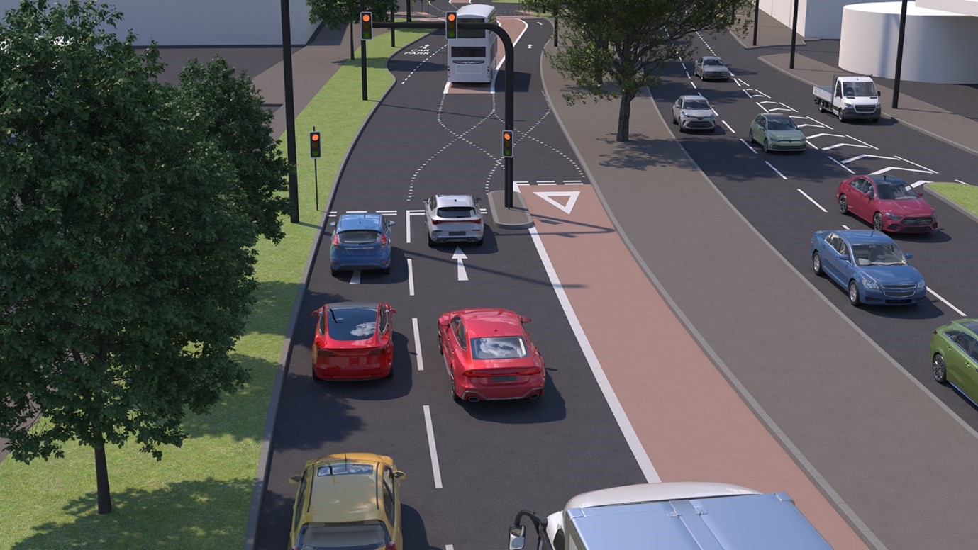
Bus prioritisation at Newfoundland Circus
Buses already travel inbound along Newfoundland Circus, towards St James Barton Roundabout, in a segregated bus lane. We're proposing to add a new set of traffic lights near Elton Street which would stop general traffic when a bus is coming. This will allow a bus to move from the far righthand lane to the left but one lane. We'll also be adding a new bus lane after these new lights to the entrance to Cabot Circus car park.
An artist's impression of what this may look like:
Trees and landscaping
Two trees would be removed to expand the road space and create a bus lane. These will be replaced in line with the Bristol Tree Replacement Strategy. We're looking at where we could plant the new trees.
The whole city centre project will see an increase in the number of trees as well as landscaping across the area.
Bus services using the bus lanes on Bond Street and Newfoundland Circus
The following services would use this route:
- 48x
- 49x
- 8
- 6
- 7
- 24
- 43
- 42
- 41
- 45
- 44
- 5
- 48
- 47
- 46
- 49
- m4
- m3
- m2
- m1
- T1
- Y1
- U3
Megabus, Stagecoach, Flix bus and National Express all use this route.
Removal of parking spaces
Eight parking spaces would be removed to make way for the proposed two-way cycleway on the south side of Portland Square, which is a one-way road. None of these 8 parking spaces are blue badge parking.
This cycle route would provide a much safer and more pleasant route from the centre to Concorde Way, which could be easily accessed from Newfoundland Road.
We carried out a parking survey in the area and found that the bays are rarely at full capacity. The average occupancy of the parking bays on Portland Square is around 40%.
Temple Way
Removal of left turn on Avon Street
The current left turn only regulation when joining Temple Way from Avon Street is being changed to a right turn only regulation. The main reason for this is to improve the links between the new University of Bristol campus behind Temple Meads and their existing campuses in and around Clifton. It may be the route of a bus service between these locations in the future. In addition, the change allows for improved pedestrian and cycling facilities to cross Temple Way here.
Why the segregated cycle lane stops at The Friary
The Bristol Temple Quarter project team is considering how cycle priority around Temple Meads can be improved as part of the changes to the station.
Until we know exactly what type of cycle priority will be built on The Friary, the Temple Way scheme will not go all the way to the junction, so no ideas for The Friary are ruled out.
The segregated cycle lane would not stop here permanently. It would join up to whatever comes forward for The Friary.
Plans for the underpass at Broad Plain
There are no plans to change the underpass as part of this project.
Removal of parking spaces
No parking spaces on Temple Way would be affected by this scheme.
No trees would be removed. We are looking at planting more trees in the area and there will be additional planting and landscaping work.
Key dates
- Start date: 12 August 2024
- End date: 30 September 2024