
Our shared vision for St Philip's Marsh is at an earlier stage, with development likely over a period of 10 to 20 years. As the project progresses, we will carry out masterplanning and further community engagement as we plan for the future of this area.
The proposals for St Philip's Marsh are designed to present flexible, guiding concepts for future employment and residential development. They're designed to inform strategic decision-making in Bristol and the wider West of England, in parallel with the Bristol Local Plan Review.
The detail provided here is at a less advanced level as further work and engagement with local business and residents is required to understand opportunities for future development.
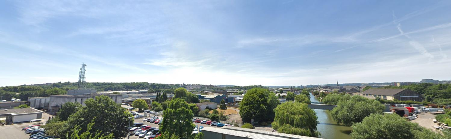
 St Philips Marsh, showing Temple Quarter regeneration areas
This is a major opportunity to transform a significant part of Bristol to create a series of sustainable, mixed-use neighbourhoods that are integrated with their surrounding communities.
Our ambition is to deliver a range of new homes, including affordable housing, along with the community infrastructure that supports wellbeing and meets the future needs of a growing city.
The area is currently characterised by industrial land and major infrastructure, and is occupied by a range of businesses from industrial and manufacturing to entertainment and cafes. There are evening venues which attract audiences from across the city and beyond. Our vision is to create new employment and business spaces that increase and diversify the jobs in the area, while exploring how to support existing businesses and employers.
There are significant opportunities here to create a low-carbon, climate adapted place to live, work and spend time. We want to put active travel, green infrastructure, and biodiversity at the heart of St Philip's Marsh. Opportunities will be considered to introduce public transport into the area, as public transport does not currently serve the area.
Sparke Evans Park, the River Avon and Feeder Canal corridors are significant green spaces and ecological assets which could all be improved. They're aspects of the character and identity of the area, however, there is little green space elsewhere. High-quality public spaces would make getting around by foot or by bike easy and safe, while public green spaces would support community health, wellbeing and access to nature.
There are a number of challenges that need to be considered. The area is susceptible to flooding requiring sensitive integration of flood defences that better protect homes and businesses while improving public spaces. There's high voltage electricity infrastructure is some areas which would need reconfiguration. The railway lines, waterways, railway arches and low bridges provide some barriers to access to and through St Philip's Marsh. Coordinating development is also a challenge due to the many landowners and occupiers.
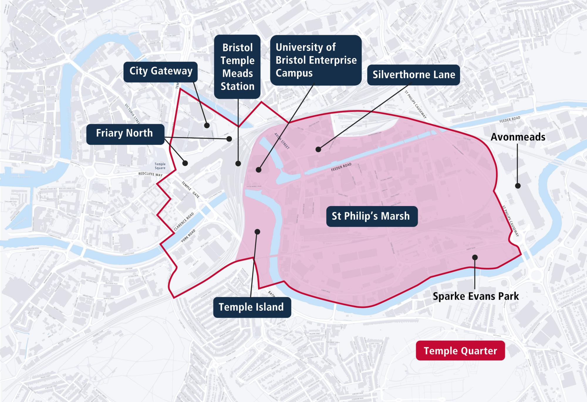
Within St Philip's Marsh, a number of projects are progressing and are at different stages of development. These are all part of the North West St Philip's Marsh area and you can find more details about the three main projects: Silverthorne Lane, Temple Island and University of Bristol Enterprise Campus, later on this page. Others include 10 Feeder Road, and the former Chanson Foods site on Avon Street. These are not subject to this consultation.
St Philip's Marsh has seen significant change over time. For centuries St Philip's Marsh was open rough grazing land. At the beginning of the industrial revolution Bristol started to expand onto the Marsh with industries and roads. By the middle of the 1800s, a small community were living and working here. The number of homes grew, and along with this a community developed which included a church, pubs and a school.
By the turn of the 20th Century the Bristol Relief Line ran across the Marsh from east to west.
In the 1960s around 6,000 people who lived in a tightly-packed community of terraced houses were relocated by Bristol Corporation to make way for commercial uses. A small number of surviving 19th century buildings and structures can be seen in the area today.
Find out more about the history of the area on The Marsh Story website (arcgis.com)
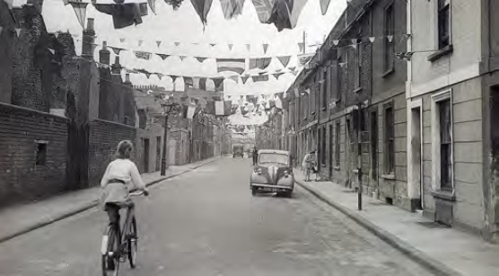 Historic image of terraced houses in St Philip's Marsh.
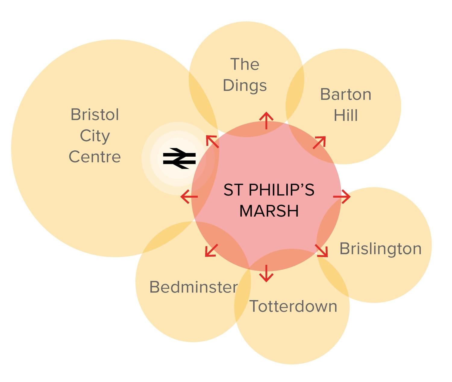
The Development Framework page sets out some guiding principles for the whole of Bristol Temple Quarter. These are the guiding principles as they apply to St Philip's Marsh.
1. Integrated and connected

- Create strong connections with surrounding neighbourhoods: reconnect communities in East Bristol, provide access to new facilities and connect new development to surrounding neighbourhoods with improved travel links.
- Support and enable low carbon mobility: provide infrastructure that promotes active travel and public transport on low traffic, low speed streets.
- Adopt an integrated design and placemaking approach to flood defence provision: flood defence design along the Feeder Canal and River Avon corridors should include habitat enhancement, landscaped areas, public walkways and cycle paths and flood resilient frontages to buildings.
- Create a resilient access and movement network: create a network of streets to ensure access and evacuation from the area in the event of major flooding.
 Integration of St Philip's Marsh with other nearby areas
2. Inclusive economic growth

- Promote a flexible approach to development plots: improve street layout, with varying size of development areas which could also include the adaptation of existing buildings.
- Establish a leading innovation district: with a variety of employment space including accommodation for start-ups, established SMEs and larger scale businesses focussed on science and technology, nanoengineering, advanced manufacturing, green economy businesses, and creative and digital industries.
- Transform existing industrial land, increasing density and diversifying land use: focus on land east of Albert Crescent where there is a need to implement flood resilient measures and to promote low carbon development.
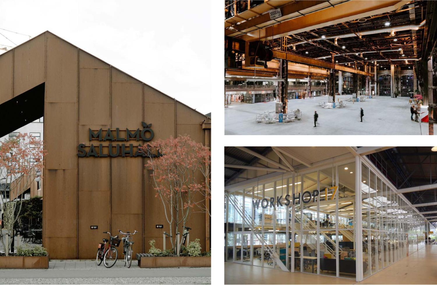 Examples of adaptive reuse of former industrial and warehouse buildings
3. Quality places
- Create a legible layout of street blocks and spaces: including establishing continuous building frontages round the edges of street blocks to improve natural surveillance of public places.
- Integrate community facilities and mixed uses from the early phases of development: to ensure adequate community facilities are in place to support new and neighbouring residents, workers and visitors.
- Carefully considered density: focus on mixed use development with opportunities to integrate residential development with employment, commercial or leisure uses within each street block. Opportunities exist for vertical mixing (where each floor has a different type of use), a mix of housing types including affordable, and street blocks with inner courtyards.
- Design buildings to last: designed and constructed to high standards, building design should incorporate green walls and roofs, and to boost biodiversity and wellbeing. Apartments and houses should be capable of adaptation over time, meeting the needs of occupiers at different life stages.
- Listed buildings should be positively integrated into future development and adapted to new uses: and opportunities should be taken for non-listed historic buildings to be integrated into development where commercially viable.
- Adapt existing buildings to new uses: to harness the character and identity of the area, have less environmental impact and create creative and low-cost spaces that attract forward thinking businesses.
4. Quality spaces

- Create a public realm of distinction: a high quality public realm network should facilitate movement within and through the area, support community health and wellbeing and enhance biodiversity. The network would include:
- an enhanced and expanded River Avon Greenway including pocket spaces, a revitalised Sparke Evans Park and integrated flood defences
- an improved Feeder Canal tow path promenade integrating flood defences
- a new park space within North West St Philip's Marsh
- Integrating green infrastructure: tree planting within public street design, incorporation of sustainable urban drainage, circulation routes within major developments incorporating significant green infrastructure, spaces and features.
- Revitalise Sparke Evans Park: to provide a welcoming and inclusive green space.
- Industrial Heritage: existing buildings and structures could be incorporated into future development and public realm improvements.
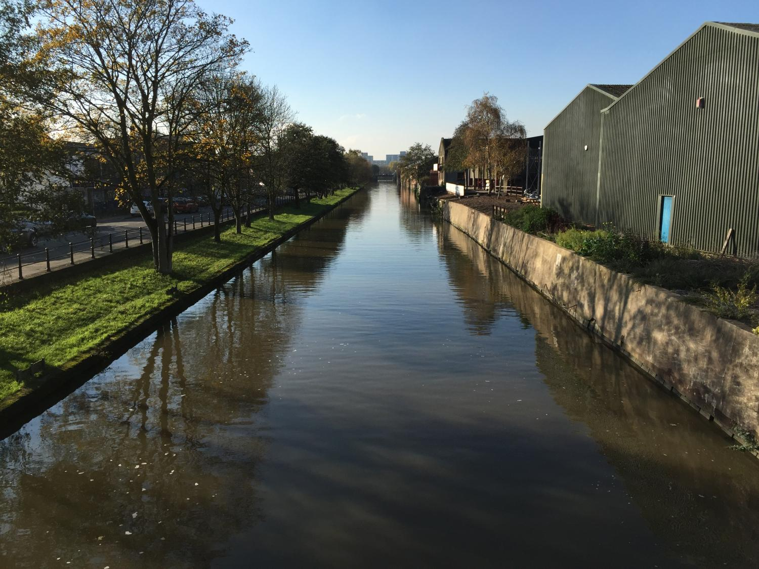 Feeder canal
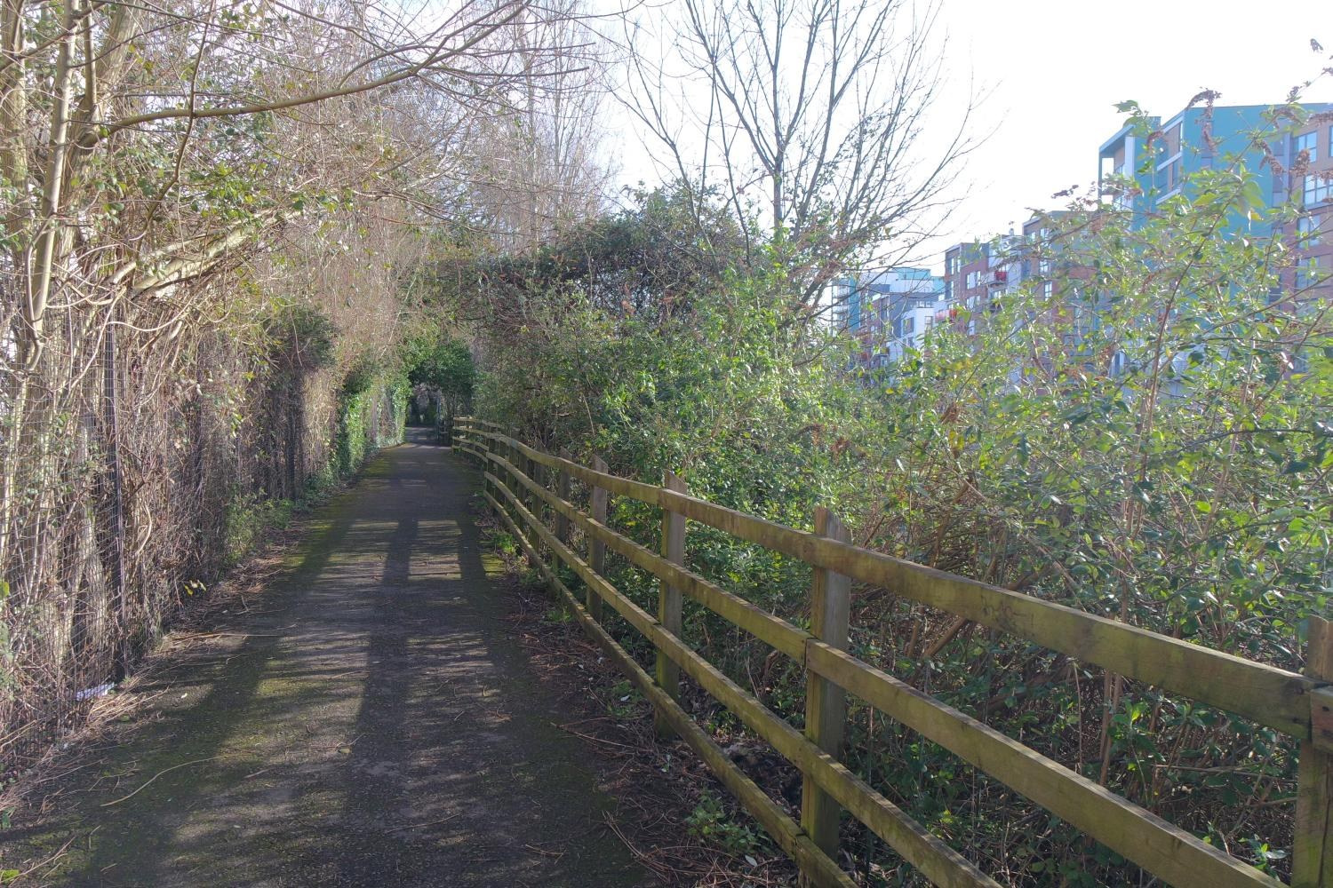 Walking and cycling path along the River Avon
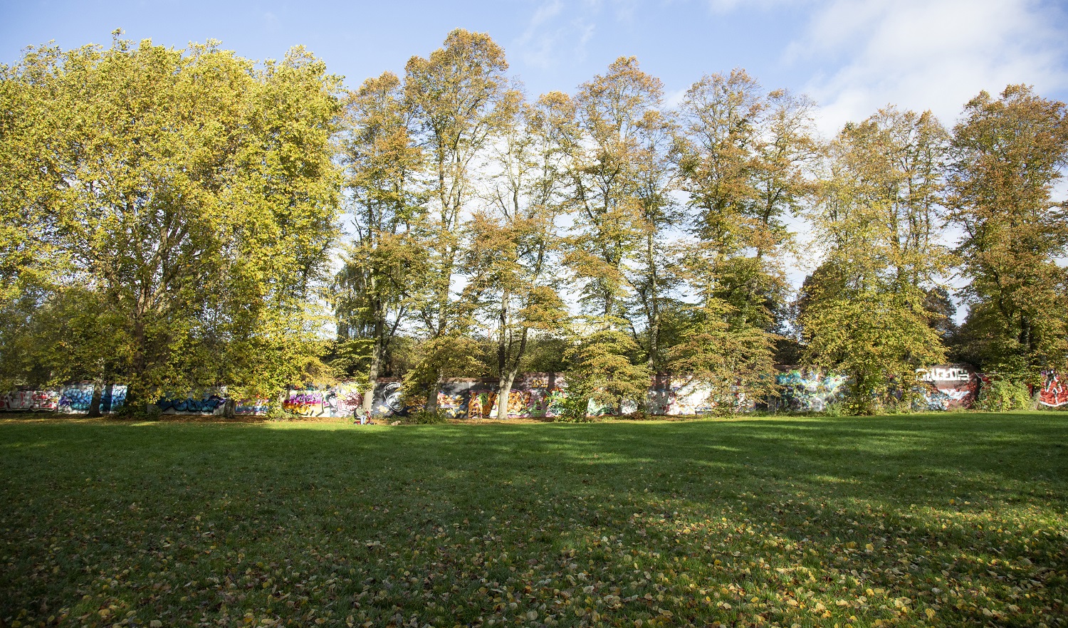 Sparke Evans Park
5. Vibrant and creative communities

- Create a vibrant new residential neighbourhood: promote residential development across the area interspersed with a range of other uses to create a successful and vibrant place. The opportunity exists to create a built and natural environment that supports low carbon lifestyles and community health and wellbeing including via new walking, cycling and public transport networks.
- There are significant opportunities to deliver a broad range of housing types and tenures including family and affordable housing, supporting the creation of a mixed and balanced community served by community facilities, local retail, food and drink and open space uses. Through residential developments there is the potential to incorporate outdoor community spaces, children's play areas and food growing areas supporting the wellbeing of existing and future residents.
Possible opportunities for redevelopment at St Philip's Marsh, the types of open space and green networks that could exist and the type of transport network, housing and business land use that may be possible.
This is a flexible concept proposal to give an idea of the change that could happen. More detail will be developed through masterplanning and ongoing community engagement. In addition to masterplanning, a cultural strategy will be produced to sit alongside this framework.
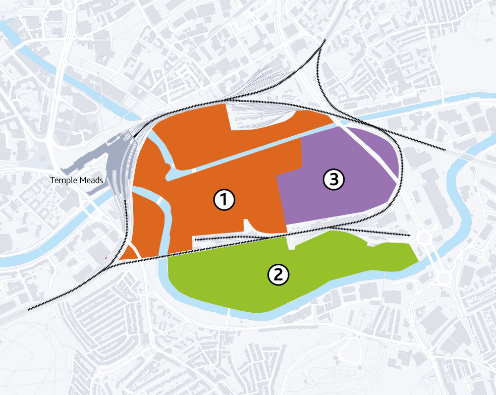
The map above shows the area covered by St Philip's Marsh, split into three areas:
- North West St Philip's Marsh: A knowledge based, employment led area focused on the proposed University of Bristol Enterprise Campus, Temple Island and Silverthorne Lane developments
- South St Philip's Marsh: A sustainable, residential led mixed-use neighbourhood focused along the new riverside linear park, integrating leisure uses and potentially including a new sporting and leisure facility
- North East St Philip's Marsh: A mixed residential and employment area providing housing and supporting uses together, including small-scale manufacturing and maker-spaces
North West St Philip's Marsh
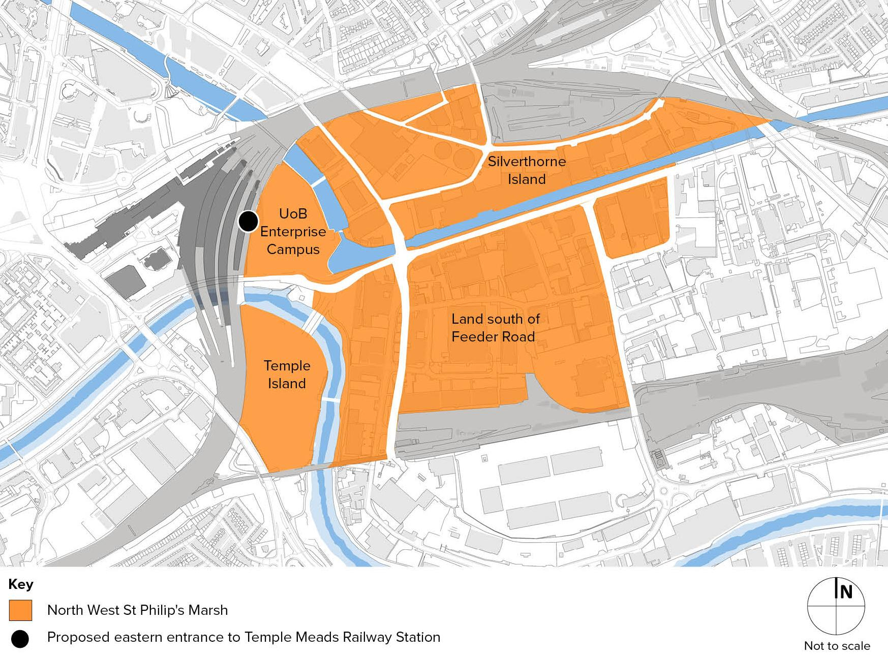 Areas within North West St Philip's Marsh
North West St Philip's Marsh area could include a mixed neighbourhood:
- building on the University of Bristol and Silverthorne Lane developments already taking place
- nurturing a creative and knowledge based economy of small and medium sized businesses which thrive on proximity to the university and each other
- contributing to a distinctive and vibrant place reflecting Bristol's independent character
Residential uses could be combined with employment uses and temporary uses where compatible. Vertical mixing of uses within new buildings, where each floor would provide a different type of use, could support the provision of a wide range of different accommodation, whilst supporting the needs of small and growing businesses across a wide range of sectors.
A number of developments are already proposed. These include University of Bristol Enterprise Campus, Silverthorne Lane and Temple Island. They do not form part of this consultation but are included here to give complete information.
Silverthorne Lane
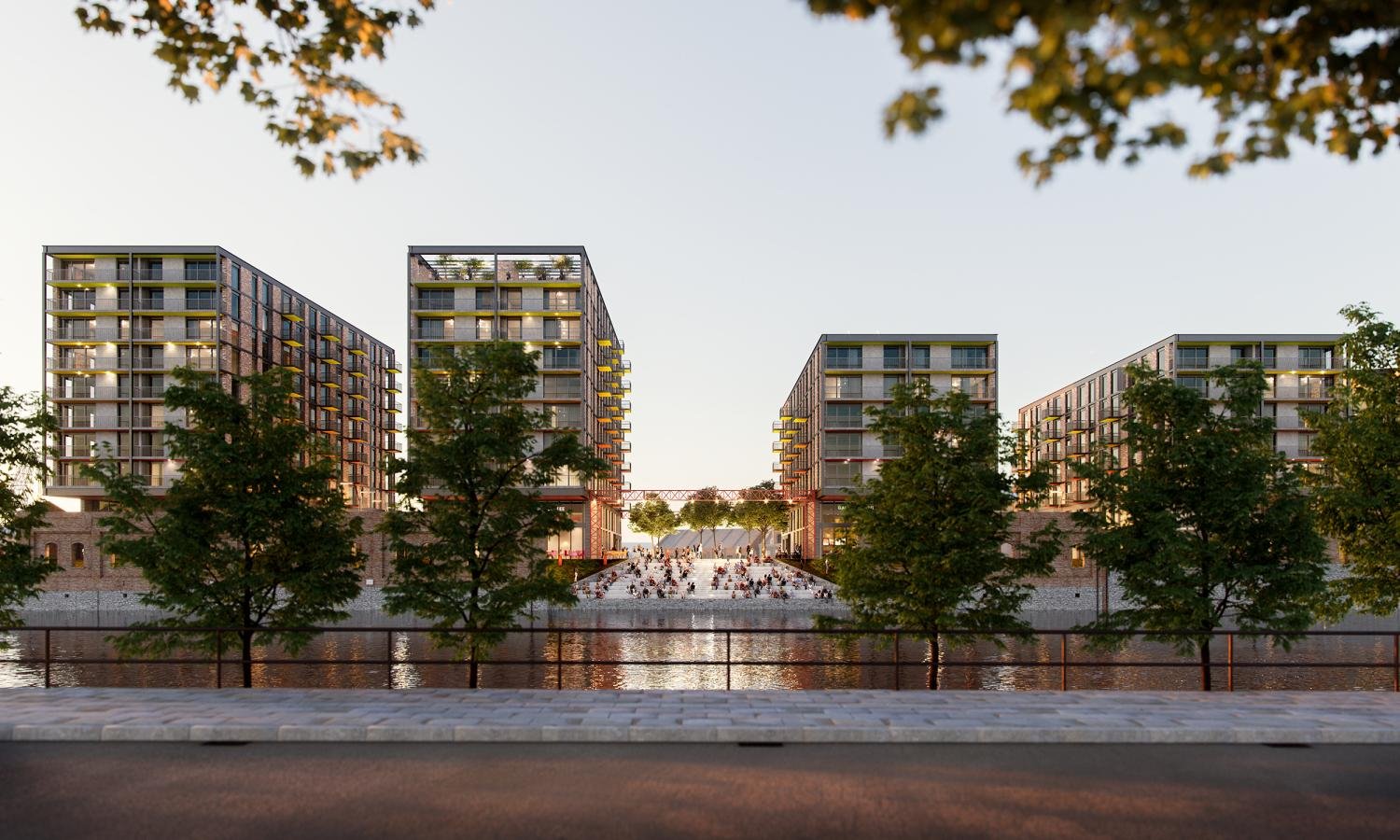 Silverthorne Lane
Consent for new development at Silverthorne Lane was granted in April 2022. The proposals include delivery of:
- a new secondary school
- student accommodation
- new homes
- employment space
- a new building for the University of Bristol
Planning applications for student accommodation have also been submitted for sites on Avon Street (approved) and Freestone Road.
University of Bristol Enterprise Campus
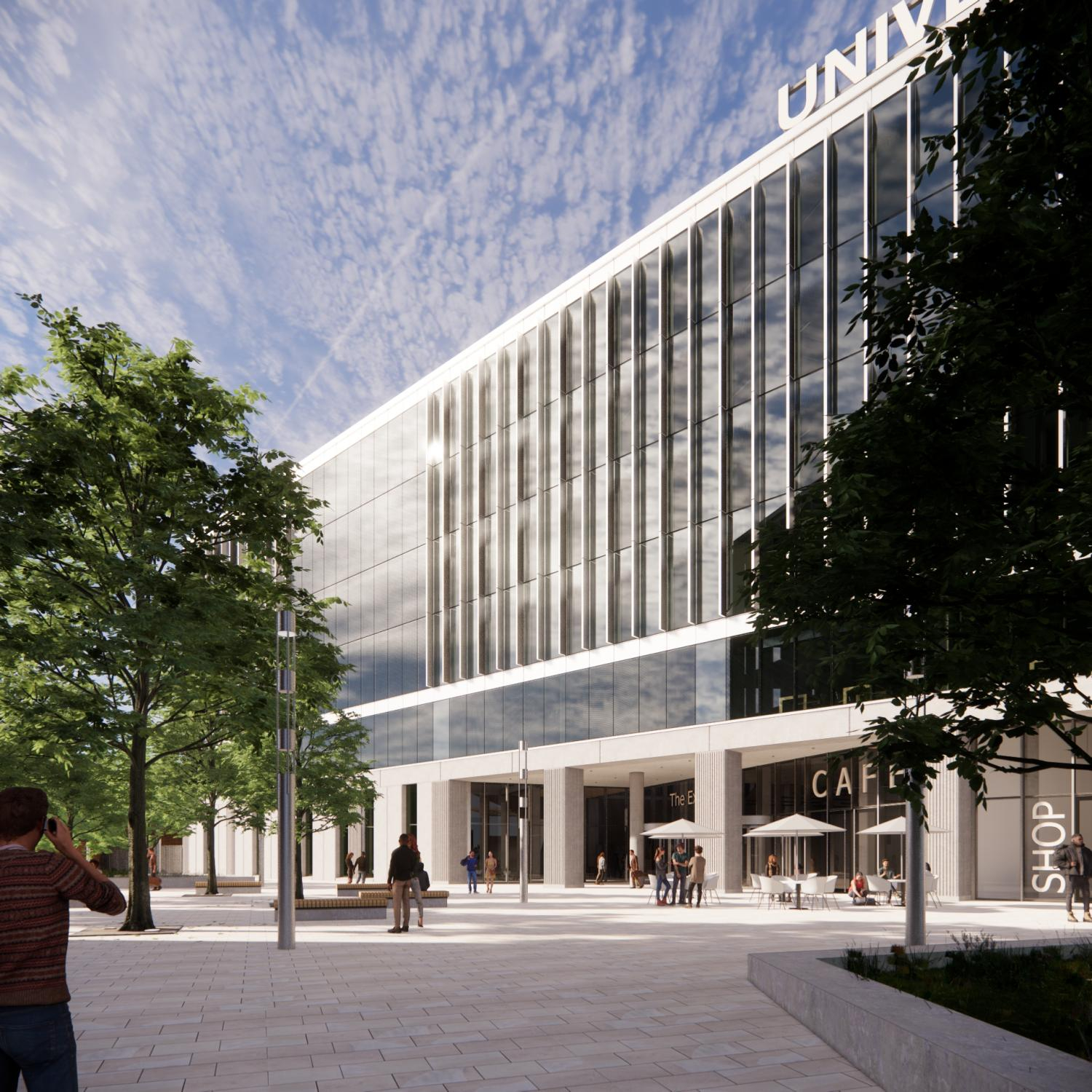 University of Bristol's proposed new Enterprise Campus at Cattle Market Road
The new University of Bristol Enterprise Campus will enhance Bristol's reputation as a global destination for innovation and strengthen the city-region's role as an economic powerhouse.
The University of Bristol's proposals are an integral part of the Temple Quarter project, and its development sites are a key driver of regeneration in the area.
The new Temple Quarter Enterprise Campus will focus on digital, business and social innovation. Bringing together world-class academic, industrial and entrepreneurial expertise, the university will innovate at scale and shape the skills the city-region needs for the future.
The new campus will provide an opportunity to create new partnerships and research collaborations that will have national and global significance. It will be a key venue for the UK digital economy, enhancing Bristol's reputation as a global destination for innovation and strengthening the city-region's role as an economic powerhouse.
The campus will be car free and the most sustainable part of the university's estate, helping to achieve its ambition to become carbon neutral by 2030.
The public realm will be an open and welcoming space for everyone to enjoy. Connected to the new eastern entrance to Temple Meads Station, the campus will have new walking and cycling routes, enabling improved access from St Philip's Marsh and its neighbouring communities to the station.
The university estimates that its new Enterprise Campus will deliver around £626m of employment and financial benefit to the regional economy over the next decade.
Temple Island
Proposals for Temple Island are for a mixed-use scheme of up to 500 new homes, student flats linked to the University of Bristol's new campus, office space, a 350-room hotel and conference facility, as well as bars, cafes and retail contributing to the creation of a vibrant place throughout the day and evening.
South St Philip's Marsh
The land south of the railway has the potential to become a new, residential-led neighbourhood capable of also accommodating a mixed-use commercial leisure development. Provision of enabling infrastructure, particularly flood infrastructure, is likely to require land assembly, where small parcels of land or property are acquired for the purpose of redevelopment of a larger area, and public investment.
Redevelopment of the area will be subject to future masterplanning, but has the potential to create:
- affordable homes of mixed tenures
- energy efficient homes
- a distinctive neighbourhood using waterfront sites
- a comprehensive walking and cycling network to promote health and wellbeing, including greenways that integrate with flood defences
- new footbridges along Bath Road and the south bank of the River Avon
- public transport routes providing access to the city centre and other neighbourhoods
- a rejuvenated Sparke Evans Park to offer community facilities such as a play area, mixed use games area, cafe, seating and planting
- a new primary school
- community facilities to support the comprehensive redevelopment of the area, including a local centre, shops, cafés, restaurants and health centre
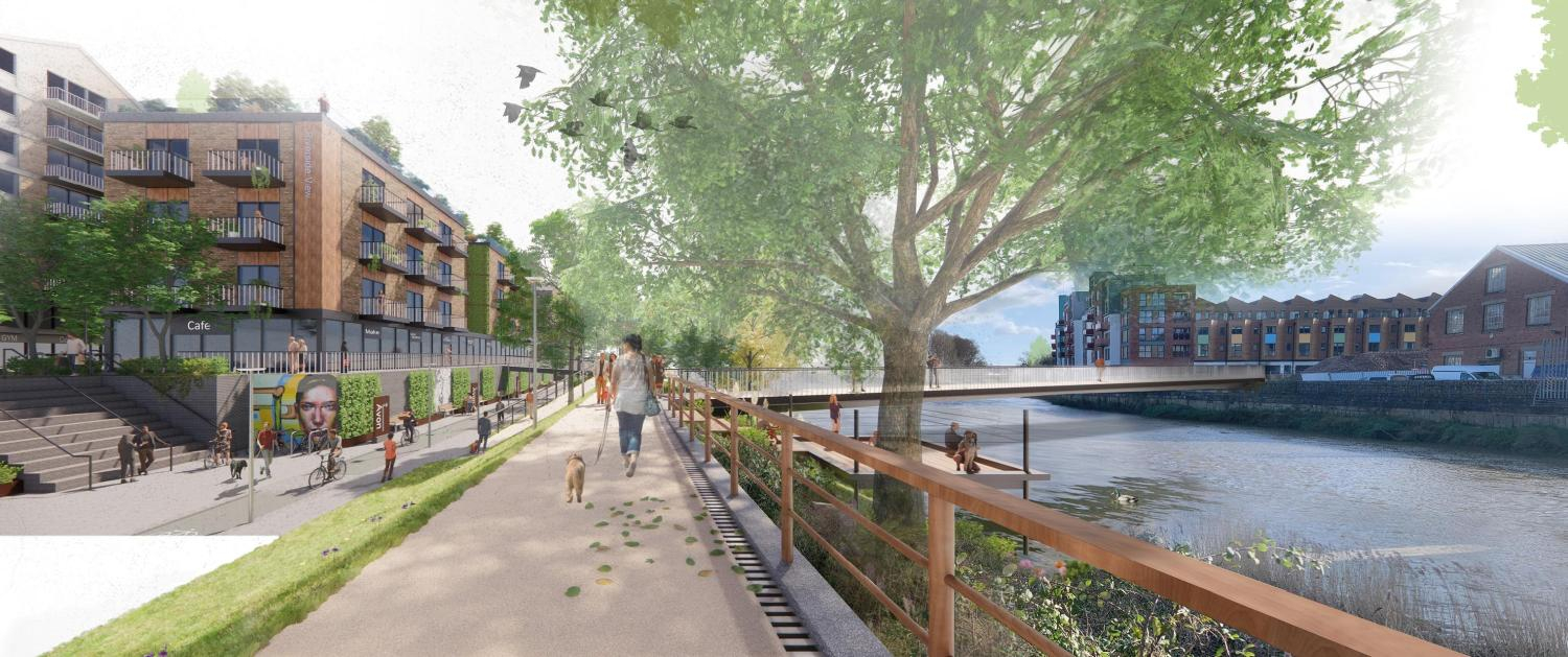 South St Philip's Marsh: illustrative view of integrated flood defence and River Avon greenway concept, showing potential bridge link to Paintworks
North East St Philip's Marsh
North East St Philip's Marsh has the potential over the medium to longer term to create more intensive employment-led, mixed-use development. As with other areas, flood defences are needed to enable redevelopment, such as along the Feeder Canal corridor.
Redevelopment of the area will be subject to future masterplanning, but has the potential to include:
- new employment, such as green businesses, digitally enabled advanced manufacturing, science and technology and creative industries
- retention of existing light industrial and manufacturing businesses relocated from elsewhere in St Philip's Marsh
- a residential community to bring vibrancy and activity, including supporting community facilities and open space
- a new pattern of streets to improve links to the north-west St Philip's Marsh area and Avonmeads Retail Park
However, significant factors that will influence land use and phasing include:
- the future of St Philip's Rail Depot, not currently considered for redevelopment
- the relationship with the elevated St Philips Causeway dual carriageway
- land ownership, with limited Bristol City Council-owned sites, and the future of existing uses by Avon and Somerset Police and National Grid (formally Western Power Distribution)
- rationalisation and realignment of electricity distribution infrastructure, including utility bridge crossings of the Feeder Canal
- potential for selective repurposing of existing buildings to accommodate new uses
Details of what could be achieved in St Philip's Marsh.
The information is structured under different themes:
- land use and density testing scenarios
- movement and access
- community infrastructure
- public realm and built environment
- open space and green infrastructure
- enabling infrastructure
To start the conversation we're exploring different uses of land at St Philip's Marsh. Three scenarios have been considered in this framework as a starting point, with a range of outcomes for the amount and type of development possible.
This should only be seen as an exploration of potential future uses to help guide responses to this consultation. Any detailed proposals will be developed during masterplanning with community and business involvement.
The scenarios are:
- Employment led mixed-use
- Residential led mixed-use
- High density residential led
The amount of development set out for each scenario explores what the implications could be for the area in terms of scale, character and community facilities.
Housing
- The scenarios test a range of possibilities including density, scale and mix of houses and apartments. All scenarios would result in a substantial new residential community.
- Affordable housing should be compliant with planning policy which sets a target of 40% affordable housing for developments of 15+ dwellings in the Bristol Inner East Affordable Housing Zone.
- Student accommodation should be guided by the limits set out in the Local Plan Review policy H7.
Employment
The mix of employment space should support a range of business types such as start-ups, creative enterprises and small-scale manufacturing or light industry, including retention and relocation of existing businesses where suitable. For the purposes of scenario testing, the amount of employment space is not based on detailed measurements.
Leisure and mixed use
Scenario 2 identifies land associated with the Bristol Fruit Market site as an opportunity for a large scale, mixed-use leisure destination. This could potentially include reconfiguration of the market to create a more visitor focused attraction including fresh food and street food markets, entertainment and education.
Local retail and services, community Infrastructure and open space are considered in further sections of the St Philip's Marsh information.
Scenario 1: Employment-led mixed use
- Residential: 2,250 dwellings.
- Mix: 30% Residential.
- Jobs: 8,000 to 10,000.
- Community mix: Mixed density residential neighbourhood supporting a broad mix of accommodation types. Up to 30% of dwellings would be houses.
- Community Infrastructure: Potential requirement for a new primary school.
- Open Space: Sparke Evans Park, enhanced River Avon Greenway and local small spaces provide sufficient space for new community.
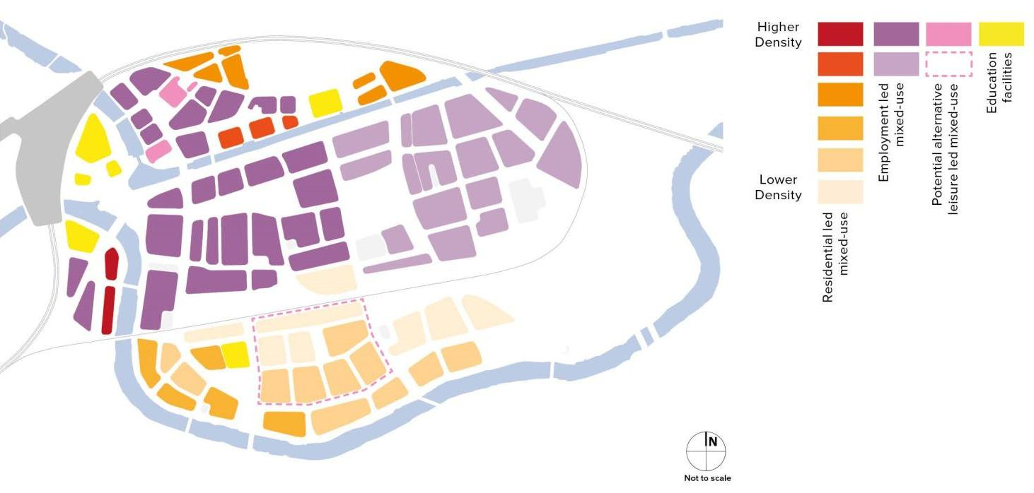 Illustration of employment-led land use and density distribution. Larger version of employment-led diagram
Scenario 2: Residential led mixed-use
- Residential: 4,500 dwellings.
- Mix: 60% Residential.
- Jobs: 4,000 to 5,000.
- Community mix: Higher proportion of apartments. Up to 15% houses.
- Community Infrastructure: Likely to require at least 1 primary school and a new healthcare centre.
- Open Space: Requires multiple new open spaces to accommodate children's play and general amenity space for residents.
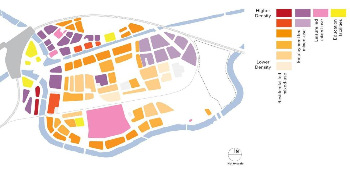 Illustration of residential-led land use and density distribution. Larger version of residential-led diagram
Scenario 3: High density residential led
- Residential: 7,000 dwellings.
- Mix: 85% Residential.
- Jobs: 3,000 to 4,000.
- Community mix: High density consisting mostly of apartments. Houses limited to 5 to 10% of mix. Opportunities for range of apartment types which support family living should be explored.
- Community Infrastructure: Likely to requires at least 2 new primary schools and a larger healthcare centre.
- Open Space: Requires multiple new open spaces to accommodate children's play and general amenity space for residents. Potential demand for more open space than shown in framework.
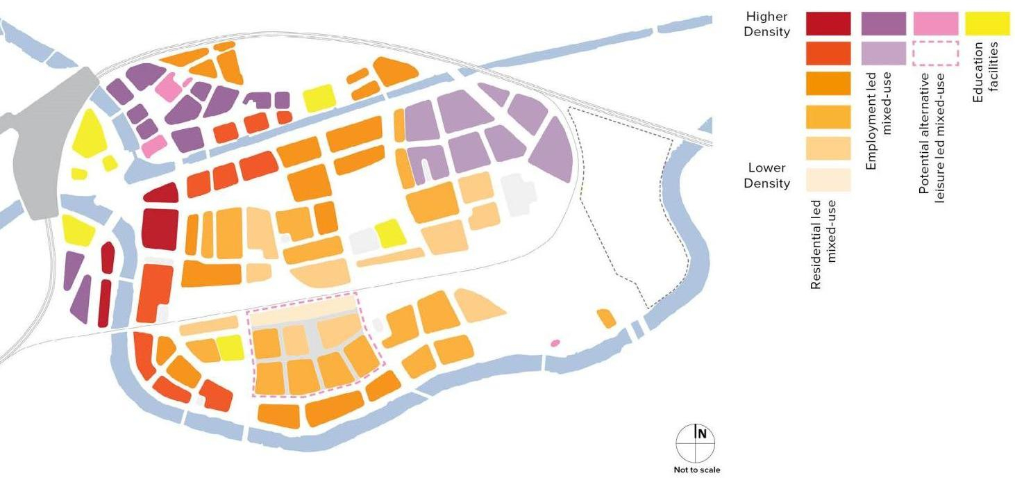 Illustration of high density residential-led land use and density distribution. Larger version of high density residential-led diagram
Optimising density
Developing at a higher density in locations such as St Philip's Marsh has the potential to support a range of objectives including:
- new homes and workplaces to meet the needs of the city and its communities
- ensuring that many people can live and work in locations that can easily be accessed by sustainable and active modes of transport
- supporting viability of active uses, business and community facilities in and around central Bristol
- making efficient use of land and reducing demand for greenfield urban expansion
Developing at higher densities can create a range of design challenges which need to be addressed, to ensure that developments create sustainable and liveable places which stand the test of time. Guidance on the planning and design of high-density development is provided in the pdf Urban Living Supplementary Planning Document(4.66 MB) .
Optimising density will likely result in buildings of a greater scale than currently in St Philip's Marsh. Opportunities for tall buildings may exist to create landmarks or enhance key views.
Providing a variety of accommodation
A variety of new homes and buildings can be designed to support a broad demographic of residents. For example, homes could include townhouses, live and work units, apartments and maisonettes.
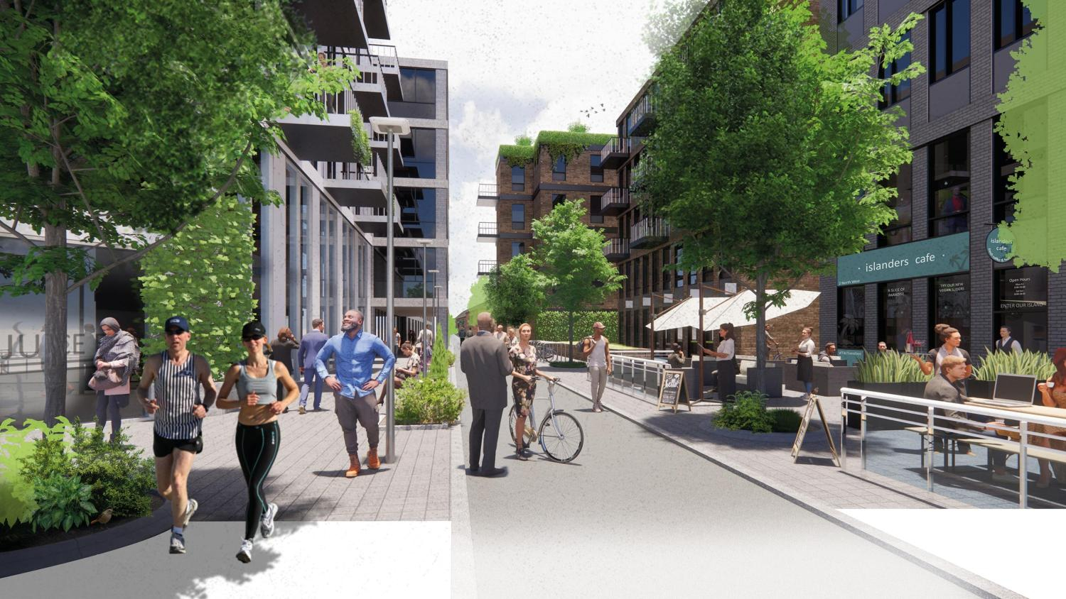
In addition, streets and spaces should provide space for people to socialise and for businesses to 'spill out'.
A variety of layouts can be considered. These illustrations show possibilities for providing residential accommodation in blocks with varying heights and types of accommodation.
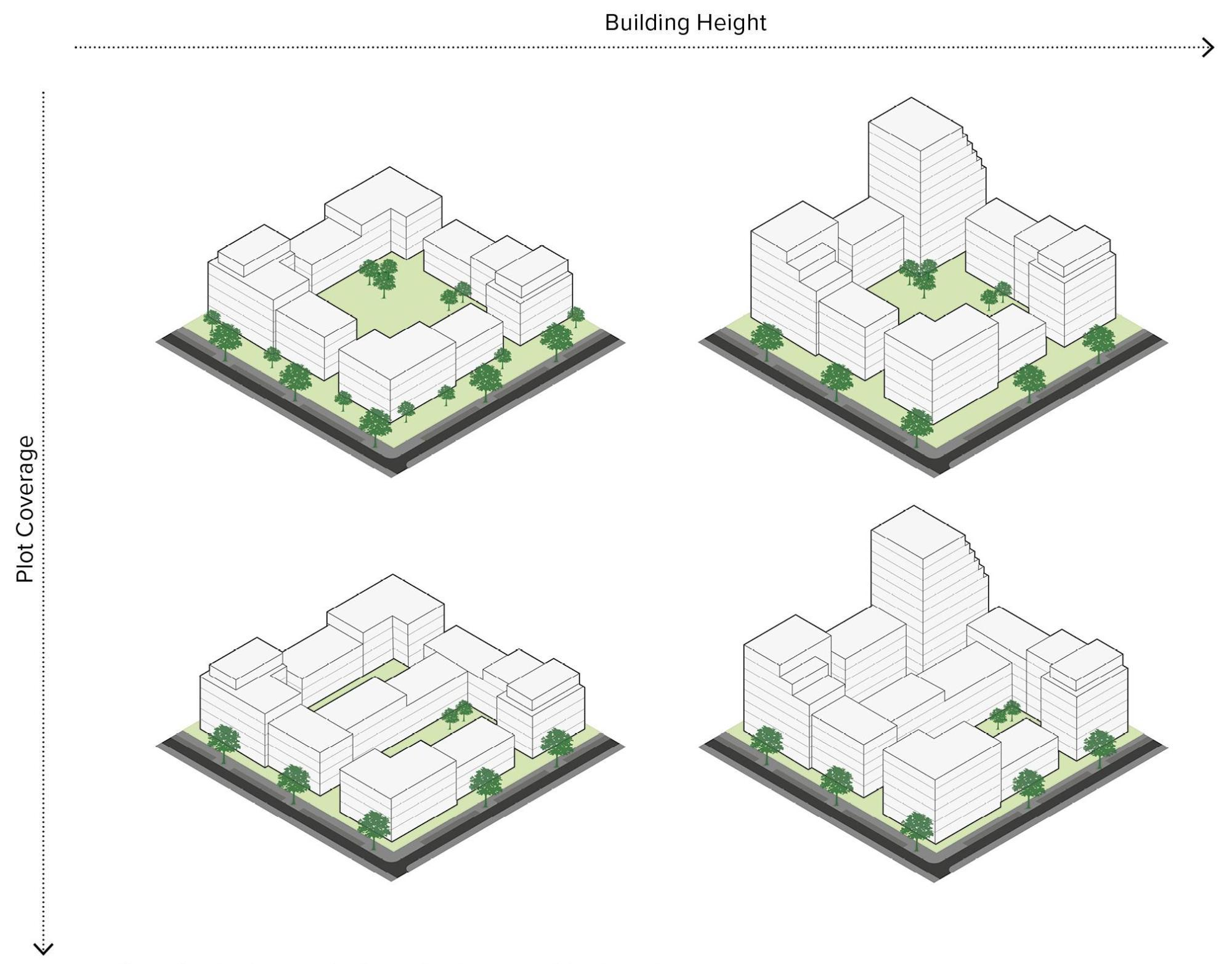 Density typologies. Larger version of density typologies diagram
It's also possible to consider a block type layout with a mix of uses as shown in this diagram:
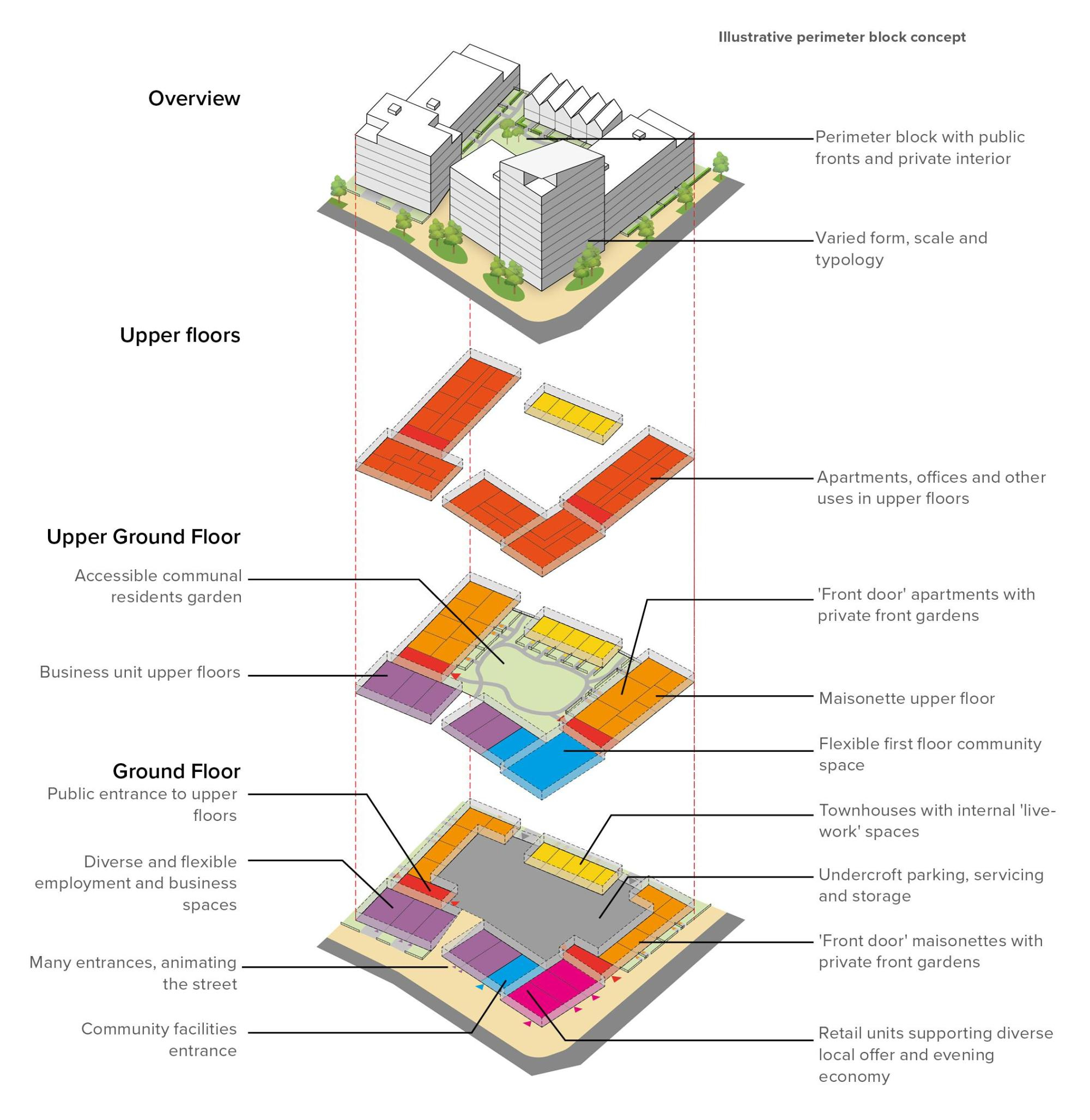 Block type layout. Larger version of block type diagram
Pop up animation
Opportunities for 'pop up' uses should be considered in design and management of the area, while larger sites such as Sparke Evans Park offer opportunities for regular seasonal markets and community events.
Re-use of existing buildings
Opportunities should be explored to retain and re-purpose existing buildings, either with long-term or meanwhile-uses as part of the phased transformation of the area.
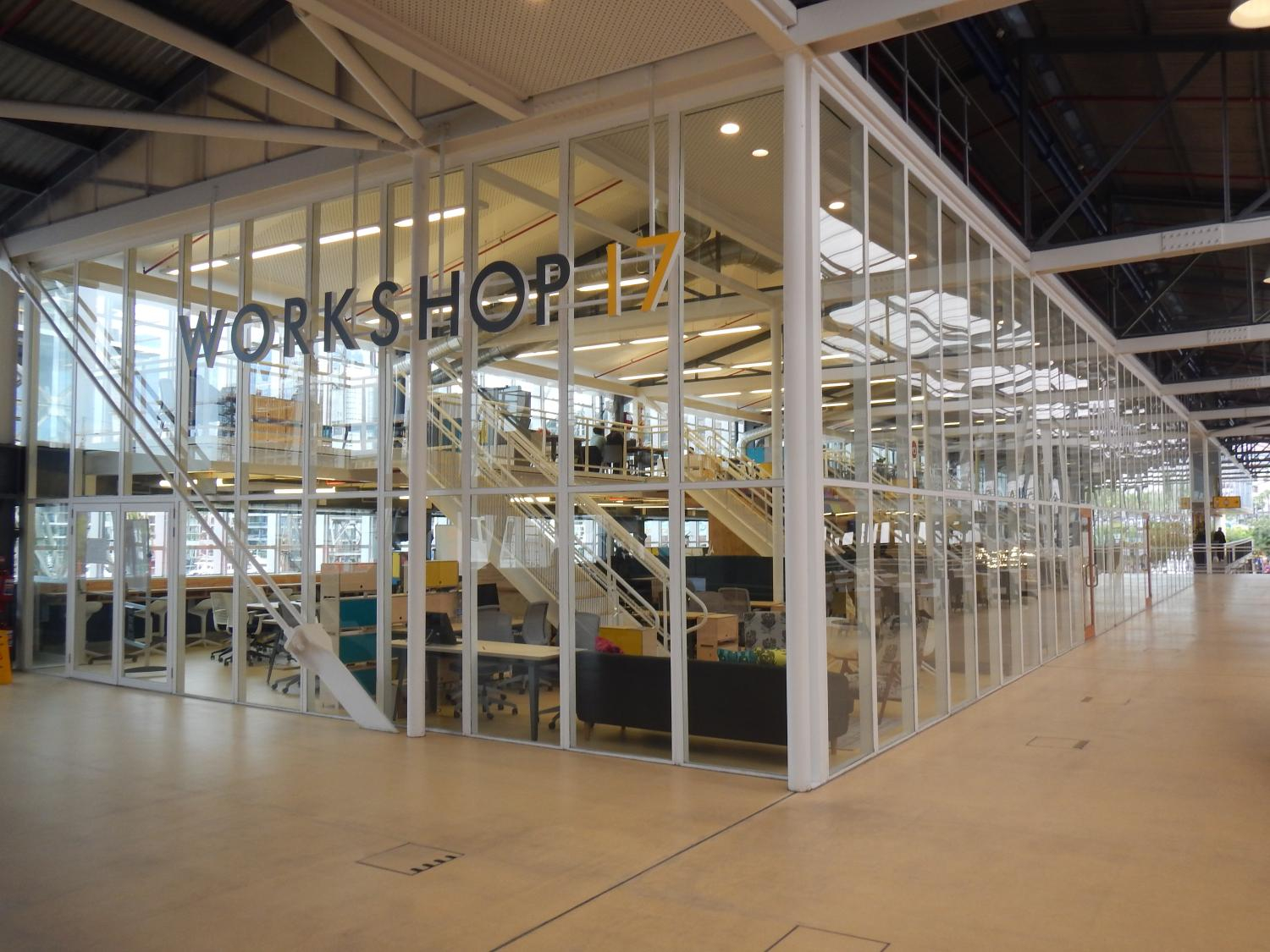 Example of re-use of an existing building.
Evening and night time
The mix of uses and design of the built environment should aim to accommodate and support a thriving evening and night-time economy. This should include a range of restaurants and bars, night markets, small-scale arts and cultural venues and spaces for performance and live music, as well as uses which support the cultural ecosystem, such as rehearsal spaces and places to store equipment.
Existing local businesses in the area, such as micro-breweries and entertainment venues, could be carefully integrated with new development and provided with opportunities for growth. Consideration will need to be given to compatibility of night-time uses with residential accommodation.
The Development Framework prioritises active travel and public transport.
There should also be safe and functional access for essential motor vehicle trips, servicing and emergency access.
This could be achieved through a range of measures:
- a network of primary streets and spaces which is easy to navigate
- a network of traffic-free walking and cycling routes along river, canal and primary streets, including quiet streets
- a range of traffic calming measures
- streets and buildings that work together to create a high-quality environment, natural surveillance and activity
- reduced car parking where possible, with prioritisation for disabled users, electric vehicle charging and car clubs
- cycle parking in all developments and throughout public realm, including e-bike charging
- frequent and reliable bus services and convenient bus stops
- wayfinding and signage
- a wide range of facilities and services within easy walking distance of residents
Possible network of travel and movement routes
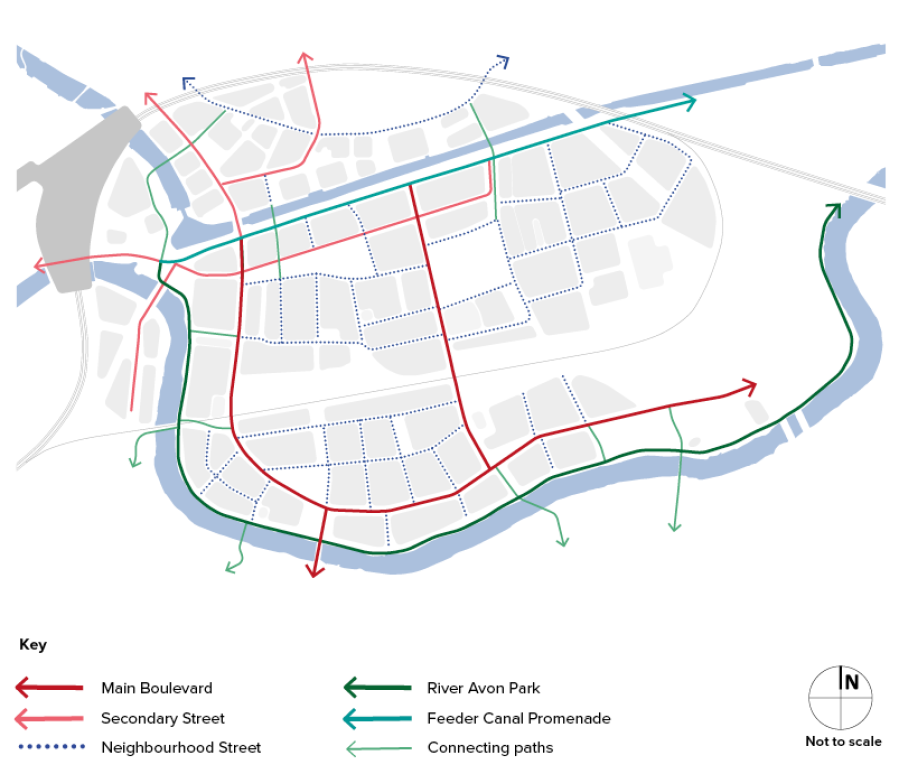 An example of possible travel routes in St Philip's Marsh. Large version of map.
The proposed layout presents a hierarchy of streets and spaces which help people to navigate the area whilst providing a functional network for all modes of travel. The hierarchy includes:
- main boulevards: direct and easy to follow routes, allowing travel and connection with the surrounding street network and green corridors
- secondary streets: functional streets supporting vehicle movement beyond the main boulevard network
- neighbourhood streets: a network of quiet streets prioritising pedestrians and cyclists while also allowing vehicle access
- River Avon greenway: a traffic free, landscape corridor with continuous walking and cycling route
- Feeder Canal promenade: A variation of the main boulevard street type, incorporating continuous walking and cycling path alongside the canal which is separated from traffic
- resilient access network: A network of raised vehicle routes to allow access and escape during flood events
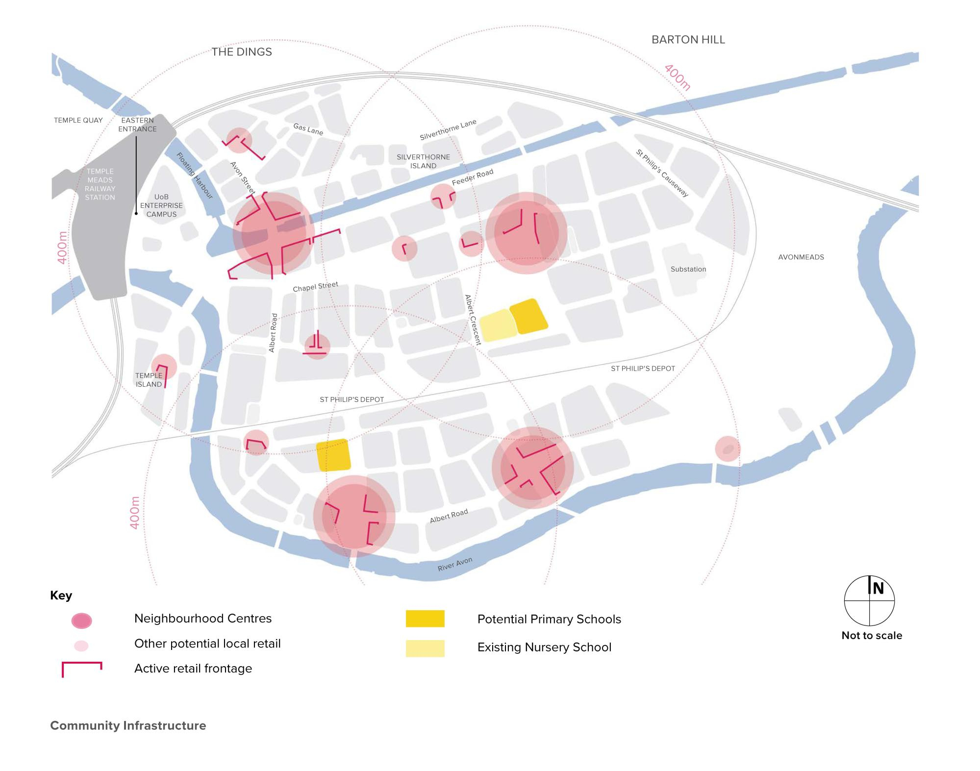 An example of how different levels of community facilities could be considered. Large version of map.
The redevelopment of the area should be supported by a range of community facilities, the extent of which will be determined by the range and density of other uses and the resulting demographic mix of the area. Community facilities should be co-located with each other, and with local retail and public open space.
 Vibrant local centres, forming the heart of new neighbourhoods.
Neighbourhood centres
Demand for local retail will depend on the employment and residential mix. Retail should be combined with a range of other uses and adaptable spaces including rentable community spaces, co-working hubs, creches and gyms.
Healthcare facilities
It's anticipated that one new GP surgery would be required and could be combined with a dental practice and other facilities.
Primary schools
It's anticipated that 1 or 2 primary schools would be required to serve the new population. Due to the dense and urban character of the area, schools should be designed to make efficient use of land and should be co-located with green public spaces to allow for reduced provision of playing fields and playgrounds. A secondary school is proposed as part of the Silverthorne Lane development.
The structure and character of the public realm and built environment should be defining elements of St Philip's Marsh. Key design principles should include:
- a variety of types of features and character
- integration of more active forms of travel and public transport
- strong frontages along streets
- active ground floor uses and 'spill out' space
- landmarks in key locations
- green spaces and features integrated throughout the public realm and built environment, supporting biodiversity, sustainable drainage and access to nature
- lighting and evening activity
- space for outside activity including facilitating markets and outdoor performance
- integration of public art throughout the built environment
- opportunities for community involvement and co-design of public realm, facilitated by local artists
Key open spaces
There should be a focal public space within walking distance of residents, which supports each neighbourhood centre. These key open spaces could include:
Parks and landscapes
- Avon Greenway: a linear riverside park providing access to nature and links to cycling, running and walking routes. Flood defences could be incorporated into the landscape.
- Sparke Evans Park: a regenerated community park with mature trees, recreation spaces, children's play spaces and a riverside cafe.
Pocket open spaces
- Neighbourhood gardens: small urban green spaces with outdoor seating, exercise equipment and children's play, co-located with primary schools where appropriate.
- Avon Greenway Connecting Spaces: small green spaces providing access and views to the riverside area.
Urban public realm
- Feeder Canal Promenade: a linear route providing access to the canal side.
- Neighbourhood squares: small urban spaces at key points in street network, with opportunities for street life and local retail.
- Main boulevards and other streets: a network of high-quality streets integrating landscaping and trees.
Recreation
- Netham Park: a large, mature park with substantial sports and recreational facilities within walking distance of St Philip's Marsh.
The information in the previous section sets out the type of spaces that could be considered. This section looks at the principles for open space and green infrastructure.
The principles for open space and green infrastructure should contribute to environmental sustainability and resilience.
Nature and biodiversity
Nature should be integrated throughout St Philip's Marsh, supporting a very significant net increase in biodiversity, and ensuring that all residents and visitors have access to natural spaces.
The design of the River Avon Greenway, Feeder Canal promenade and railway embankments should be enhanced as wildlife corridors.
In addition, railway embankments make important contributions to wildlife in the area and should form part of an emerging network of corridors.
Streets and open spaces present opportunities for native planting including wildflowers, grassland and trees.
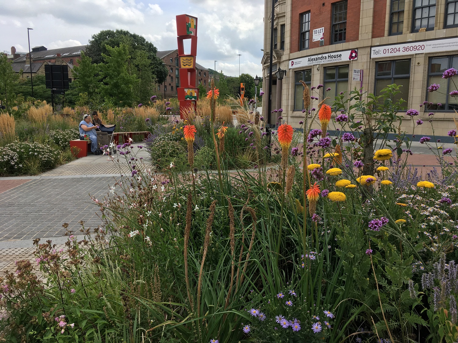 Example of landscape designed for biodiversity and water resilience: Grey to Green, Sheffield
Enhanced and resilient waterways
Regenerating St Philip's Marsh provides the opportunity to enhance the River Avon and Feeder Canal corridors as significant open space and green infrastructure. These waterway corridors have the potential to become significant attractions for the wider city. Opportunities include play and exercise trails, riverside walkways, seating and boat moorings. The area is currently subject to significant flood risk, which will be addressed through provision of new infrastructure. Flood defence infrastructure must be carefully designed and integrated with the waterside landscape to ensure that the sense of connection between the city and the water is not lost.
There are opportunities for features such as rain gardens and sustainable drainage throughout the area.
Play, sports and recreation
Formal and informal play facilities to meet the need of all ages and abilities should be located throughout the area. Total provision should meet or exceed Bristol City Council's policy of 10sqm per child. In addition, formal recreational spaces could include courts and multi-use games areas (MUGAs), to complement facilities at Netham Park.
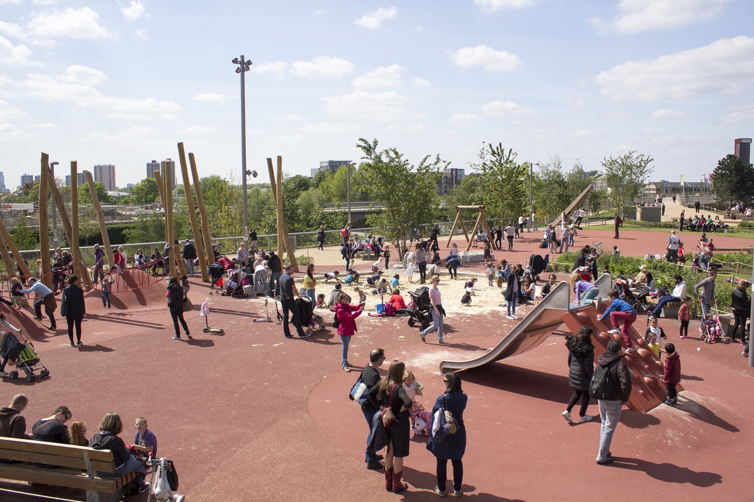
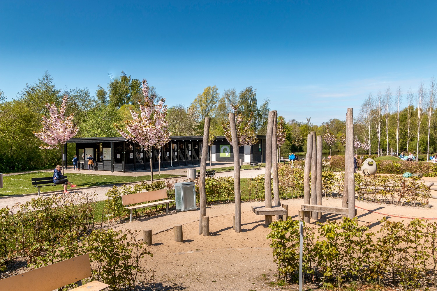
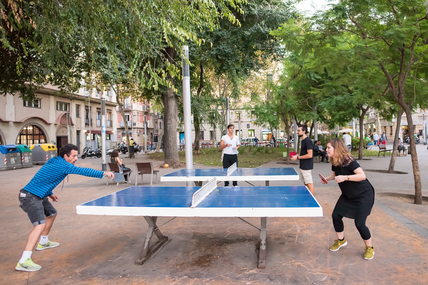
Examples of imaginative play spaces:
Green buildings and blocks
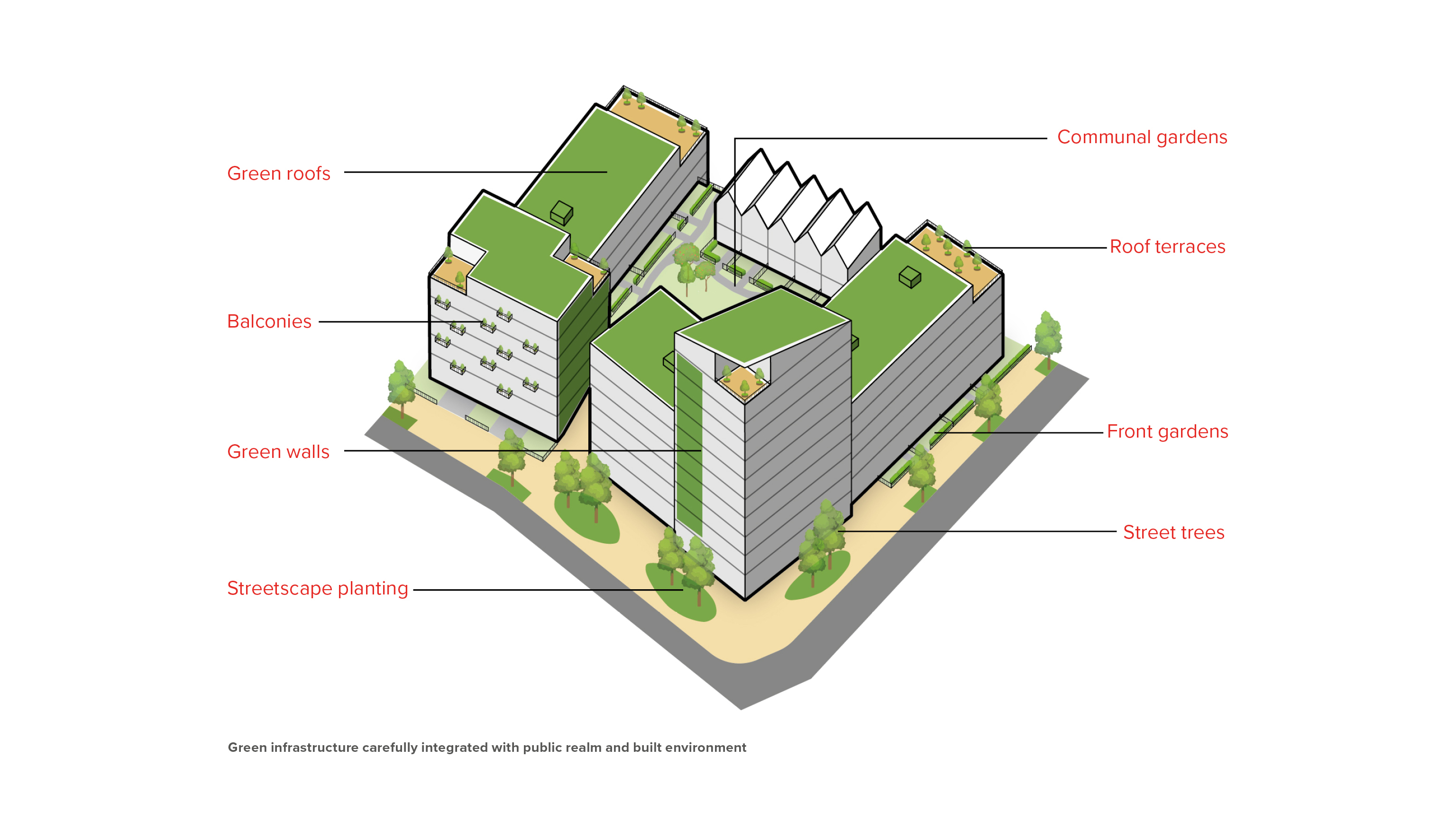
Opportunities should be explored within designs including communal gardens, roof terraces, balconies, front gardens, green roofs, and street planting.
The transformation of St Philip's Marsh set out in the Development Framework will depend on significant investment in new infrastructure. This could also require land acquisition and relocation of existing businesses. Key infrastructure and works to enable redevelopment could include:
- flood defences: currently envisaged by Bristol City Council as being along the south side of Feeder Canal and north bank of the River Avon
- a Resilient Access Network: a network of streets above flood levels to provide safe access and egress
- land remediation for contamination
- district heating
- pumping stations, drainage and utilities
- bridges to improve access and walking and cycling connectivity