We're starting to plan a liveable neighbourhood in the areas of Southville, Bedminster, Ashton Vale, Malago Vale, Perrets Park, Windmill Hill and Totterdown.
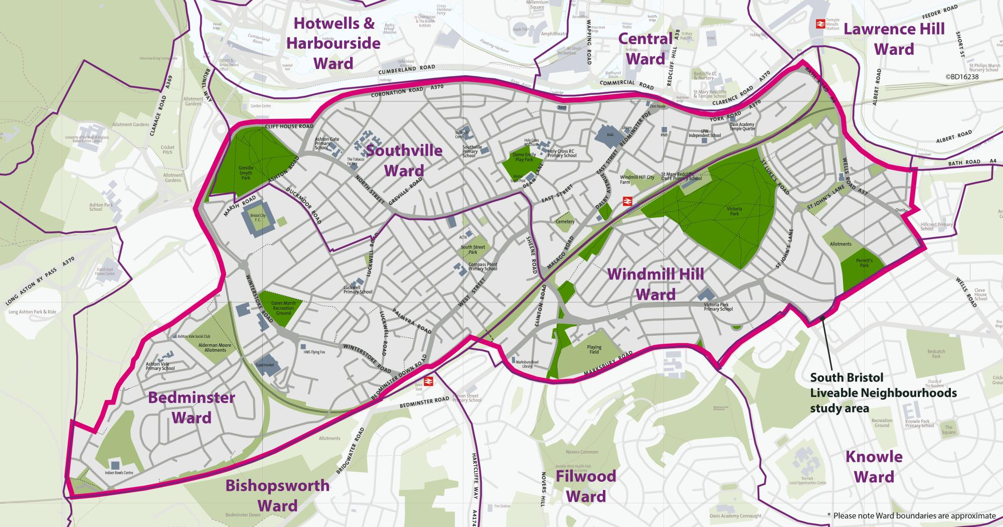
These areas have been chosen because people who live here tell us about the challenges they face with traffic.
We're working with people who live, work, study and travel through these areas to design improvements that will make the streets more people-friendly. Our aim is to design safer and quieter streets to encourage people to walk, cycle and wheel for shorter journeys, improve air quality, enhance the public realm and green spaces, and improve access to local high streets.
We're at the early planning stages of the project. Earlier this year, we started planning by collecting data on traffic, air quality, noise and other information.
Measures that could be installed include:
- modal filters
- bus gates
- pocket parks
- changes to one-way and two-way traffic flow
- cycle hangars
- trees in large planters
- street lighting
- signalised crossings
- footway improvements
- planting street trees (we'll be trialling some trees in large tubs)
- sections of protected cycle track
Driving routes may change, but it will not stop you accessing any of the area by car.
Funding from WECA
Funding was made available from the West of England Combined Authority (WECA) to develop a business case for a liveable neighbourhood.
Community engagement
There have been calls for liveable neighbourhoods in south Bristol from local councillors and people in the community. The project will build upon learnings from the East Bristol pilot.
Near to the city centre
The project area is within a short walking and cycling distance of the city centre, which makes walking, wheeling, cycling and scootering a realistic option for commuting journeys.
Near other major developments
The area is near to and contains major developments, such as Bedminster Green and Temple Quarter. Since 2010, 3,250 new homes have been approved in the planning system within Bedminster, Southville and Windmill Hill. There have been a further 10,000 new homes approved in the immediate surrounding wards. These developments are likely to attract more car journeys, which cannot be accommodated by the transport network.
We need to support and accommodate this future growth as sustainably as possible, while also minimising the impact motorised traffic has on residential neighbourhoods and busy high streets.
Near the Clean Air Zone
The project area is close to the boundary for the Clean Air Zone, which launched in November 2022. Concerns have been raised that additional vehicles may cut through the area to avoid the charges, which will increase the transport issues that have already been reported to us.
Near to walking and cycling routes
Encouraging and enabling more people to use sustainable forms of transport, particularly walking and cycling, helps ease pressure on our public transport and road systems, which are often operating at capacity.
The project area is close to walking and cycling routes, such as the Malago Greenway and Filwood Quietway, which are often very busy at peak times. Improving alternative routes can help alleviate this pressure.
Walking and cycling reduce road danger and improve personal mobility and public health. They're also the 2 cheapest forms of transport and are therefore accessible and inclusive to the broadest range of people in society.
Better for bus reliability
Local bus services can be impacted by congestion when routing through residential streets. Improving bus reliability will help more people to use the bus on a regular basis.
Other transport and regeneration projects in and around the South Bristol Liveable Neighbourhood project area.
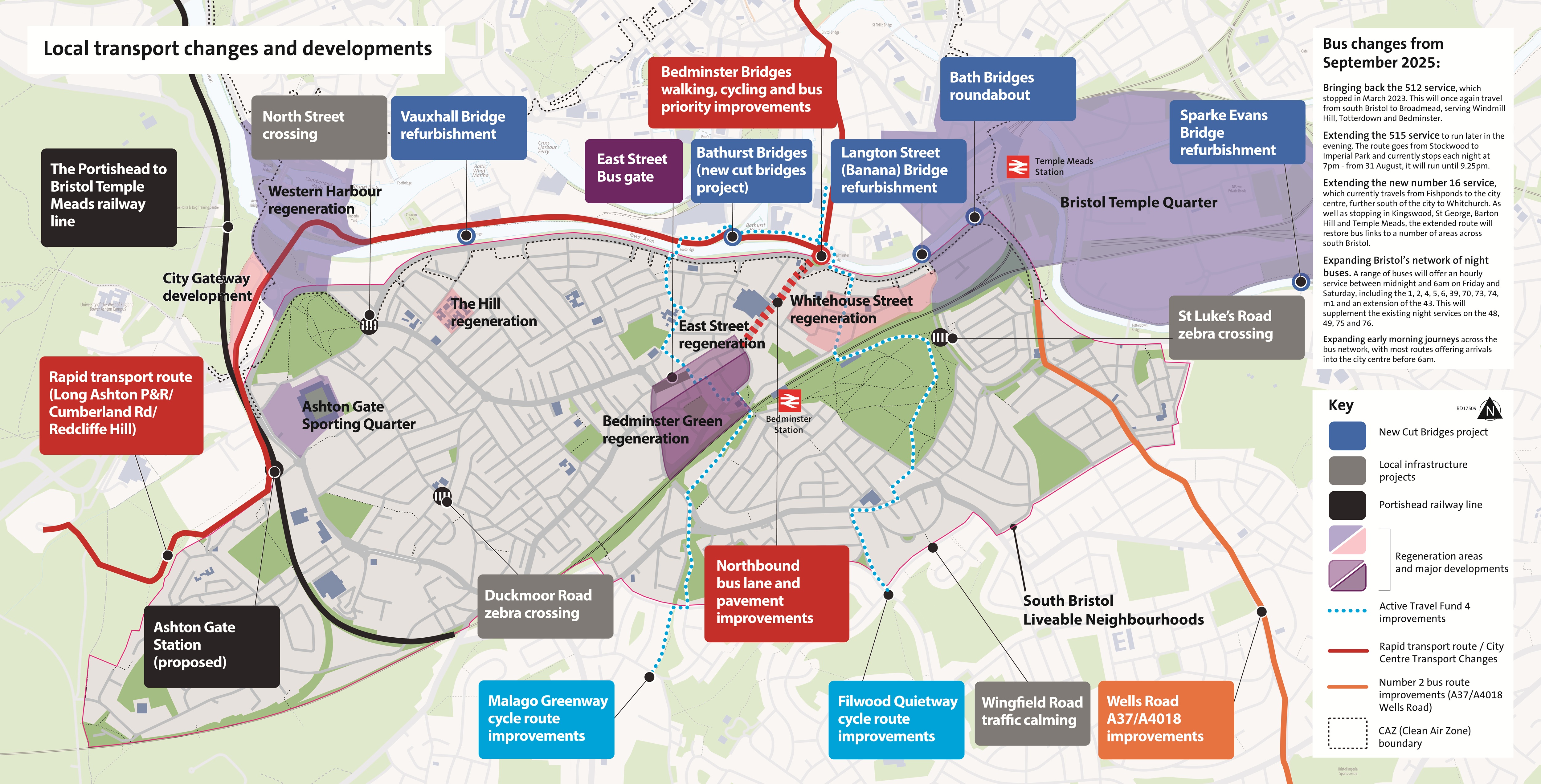
Dean Lane
Improvements to walking, cycling and the general street environment.
Bedminster Green
Transport improvements and river restoration works in Bedminster Green.
Bedminster Green - East Bedminster Regeneration.
Malago Greenway and Filwood Quietway
Proposed improvements to walking, wheeling and cycling routes in Bristol.
Active Travel Fund 4 Walking and Cycling Schemes
Mead Street Regeneration
Revitalisation of the area around Mead Street, near Bristol Temple Meads.
Mead Street - Bristol Temple Quarter
Whitehouse Street
Regeneration of the area around Whitehouse Street in Bedminster.
Whitehouse Street - East Bedminster Regeneration
Improvements to the number 2 bus route
Improvements to the A37 (Wells Road) bus corridor.
Find out more on the Bristol on the Move website.
Clean Air Zone
Charging zone for non-compliant vehicles.
St Luke's Road crossing
Community Infrastructure Levy funded zebra crossing.
St Luke's Road - Proposed Zebra Crossing
Duckmoor Road crossing
Community Infrastructure Levy funded zebra crossing
Vauxhall Bridge and Bedminster Bridge Roundabout (twin bridges)
Restoration of bridges that cross the New Cut of the River Avon.
Liveable neighbourhoods are areas of a city that are improved to be people-centred and more 'liveable'.
They're safe, healthy, inclusive and attractive places where everyone can breathe clean air, have access to better quality green spaces and safe spaces to play and feel a part of a community.
The improvements in a liveable neighbourhood aim to make it easier to catch a bus and to walk or cycle, with improved infrastructure and less through traffic.
Designing changes with the local community means they'll meet local needs, this is known as 'co-design'.
The improvements can be small scale and easy to install, such as:
- planting trees
- adding planters
- providing more benches
- creating community activity spaces
- adding crossing points
- putting in better lighting
How are liveable neighbourhoods more inclusive
Liveable neighbourhoods are designed with the aims that all residents, no matter their background, ability, gender or age, feel safe to walk and cycle and all amenities and public transport are within a short walking distance, where people don't need to drive a car to commute, shop or drop children at school.
Bristol is growing. We need to support and accommodate future growth as sustainably as possible, while mitigating the impact traffic has on neighbourhoods and busy high streets.
We want to make neighbourhoods safer and more accessible for residents, businesses and visitors, whether they walk, use public transport, cycle or drive.
Bristol's Citizens' Assembly, alongside information from residents, reveals a strong desire to improve neighbourhood areas to make them more liveable.
Quality of life in Bristol
Bristol One City
Encouraging and enabling more people to use sustainable forms of transport, particularly walking and cycling, helps ease pressure on our public transport and road systems, which are often operating at capacity. Walking and cycling are also the two cheapest forms of transport and are therefore accessible and inclusive to the broadest range of people in society. Also, the more people walk or cycle, the more personal mobility and public health is improved and road dangers are reduced.
In the One-City Plan, Bristol committed to becoming carbon neutral and climate resilient by 2030. Evidence from other authorities across England has shown that liveable neighbourhoods are an effective tool for replacing short car trips with walking and cycling journeys. Improving active and sustainable travel is a key component in how Bristol can achieve its aim of becoming carbon neutral and climate resilient by 2030.
Benefits of living in a liveable neighbourhood can include:
- more opportunities for neighbours and children to socialise and take part in unstructured play
- quieter, more pleasant streets
- an active and healthier population
- less isolation
- more trees, flowers and greenery
- safer for children to get to school
- cleaner air to breathe
Health
Liveable neighbourhoods can lead to fewer people owning cars, which is linked to a reduction in traffic related pollution. And walking and cycling are shown to decrease rates of asthma, depression, diabetes and increase life expectancy.
Road safety and crime
Reducing the speed and amount of traffic on roads has a significant impact on road injuries and crime. By creating more high quality community spaces, that people want to spend time in, crime and anti-social behaviour also tends to reduce.
Disabled people
Liveable neighbourhoods aim to make the street environment inclusive and inviting. They can bring significant improvements to accessibility, including:
- benches
- unobstructed and clearer pavements
- signage
- car parking for Blue Badge holders
They look to share space between everyone, while preserving car access. Where possible, additional disabled parking bays will be installed next to community facilities so that it's more convenient for Blue Badge holders to access.
Traffic
A liveable neighbourhood is made up of residential streets surrounded by connector roads. Connector roads are more suitable for carrying greater volumes of traffic through an area. Measures are put in place to stop people using residential streets to cut through the area, moving them back onto connector roads.
Residents
All addresses within the area will still be accessible by car, although your route may change.
If you're walking, cycling, taking the bus or train, your journeys will not change and should become more pleasant.
Businesses
Evidence suggests that liveable neighbourhoods have no significant negative impact on business and retail. There's mounting evidence of positive effects on retail sales, rental value, and tax revenue.
Retailers sometimes overestimate the importance of customers arriving by car with many of their customers living nearby and arriving by foot.
Emergency services
The liveable neighbourhood will be accessible by emergency services although some routes may change. Emergency services can use bus gates. We'll continue to engage with emergency services on the detailed design of the scheme and will take all feedback seriously.
Trade and delivery vehicles
Trade and delivery vehicles can still access the whole area by vehicle although their route may change.
The pdf Liveable Neighbourhoods handbook(210 KB) gives an overview of the design and engagement principles for liveable neighbourhoods. It's a living document that will be updated to include lessons from:
- the East Bristol Liveable Neighbourhood trial
- the South Bristol Liveable Neighbourhoods as they develop
- examples from across the country
In the handbook, we set out a clear and consistent description of liveable neighbourhoods. This can help local councillors and communities have informed conversations about these projects and whether they're appropriate for their local areas.
The handbook is not intended to be used by groups to develop proposals for a liveable neighbourhood in their area without council input.