Transport Committee has approved new 20mph speed limits in parts of the city to help improve road safety.
The decision was based on:
- the latest evidence of the benefits of 20mph speed limits
- a public consultation, with more than 5,000 responses
Find full details of the evidence and consultation in the Transport and Connectivity Committee report, October 2026.
The next phase of this project will involve detailed design work and Traffic Regulation Orders for the public to comment. This will help us to make any final changes before the new speed limits are introduced.
The maps in this guide show the roads where new 20mph speed limits are proposed.
The final details of the new speed limits will be shared as part of the Traffic Regulation Order process.
If your area is not shown, that means there are no changes proposed as part of this project.
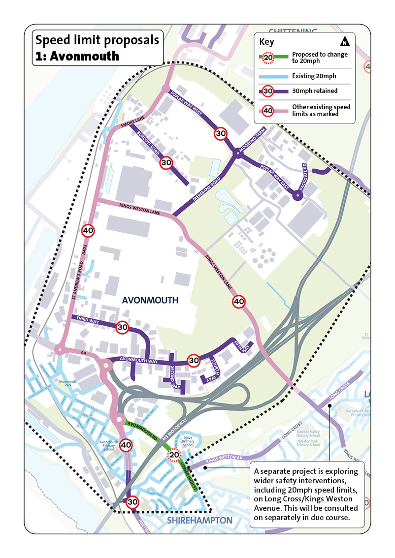
This area covers Avonmouth in north-west Bristol. It is a mix of work sites, warehouses, and transport links.
Most homes are in the south, near Avonmouth train station.
Proposed roads to change to 20mph
- Avonmouth Road
- Lower High Street
Other projects
A seperate project is exploring wider safety interventions, including 20mph speed limits on Long Cross and Kings Weston Avenue. This will be consulted on separately in due course.
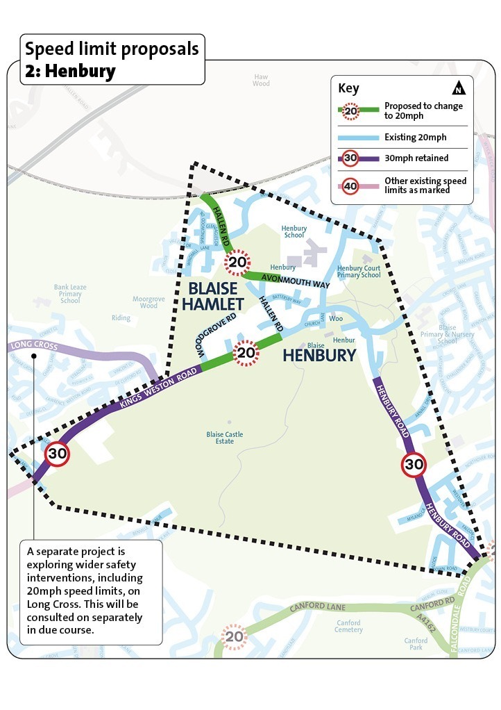
This area covers Henbury in north-west Bristol, including Henbury, Blaise Hamlet and the roads around Blaise Castle Estate.
It is mainly a place where people live, with local streets, green spaces and nearby schools.
Proposed roads to change to 20mph
- Henbury Road
- Kings Weston Road, from Hallen Road to Woodgrove Road
Other projects
A seperate project is exploring wider safety interventions, including 20mph speed limits on Long Cross. This will be consulted on separately in due course.
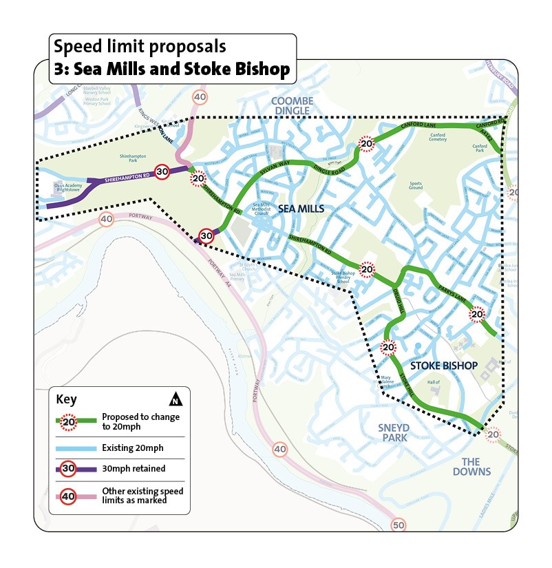
This area is in north-west Bristol. It includes Sea Mills, Coombe Dingle and Stoke Bishop.
It is mostly a place where people live. There are local shopping streets on Shirehampton Road and Druid Hill, and green spaces such as Shirehampton Park, Sneyd Park and The Downs.
Proposed to change to 20mph
- Canford Road
- Canford Lane
- Dingle Road, and Sylvan Way (the A4162 from Falcondale Road until Woodleaze)
- Shirehampton Road and Parry's Lane, from Kings Weston Road to the existing 20mph speed limit at Cross Elms Lane Druid Hill and Stoke Road
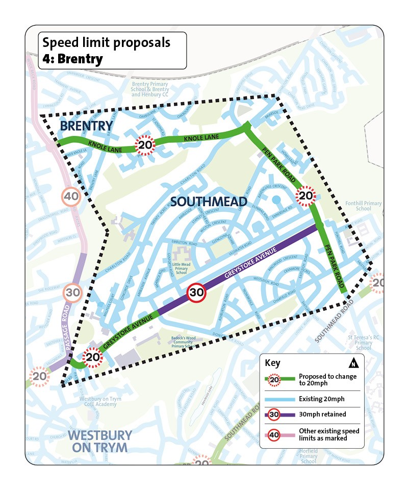
This area covers Brentry in north Bristol and northern parts of Southmead.
It is a place where people live with green spaces and local schools, including Brentry Primary School, Little Mead Primary Academy, and Fonthill Primary School.
Proposed to change to 20mph
- Knole Lane
- Pen Park Road
- Greystoke Avenue between Passage Road and Doncaster Road
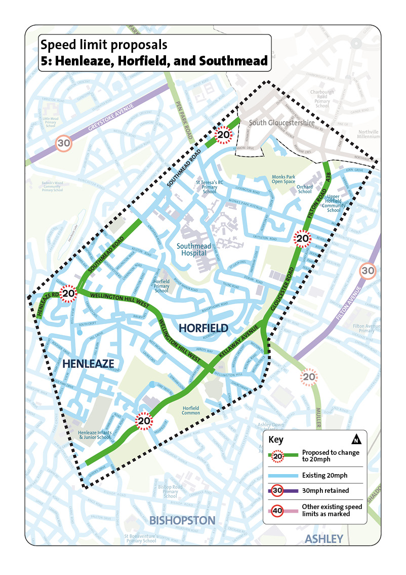
This area includes Henleaze, Horfield and parts of Southmead in north Bristol.
It is a place where people live, but a lot of people drive here to visit Southmead Hospital or pass through when travelling from South Gloucestershire to central Bristol.
Proposed roads to change to 20mph
- Gloucester Road and Filton Road
- Kellaway Avenue
- Wellington Hill West
- Southmead Road (two sections proposed for 20mph)
- Henleaze Road
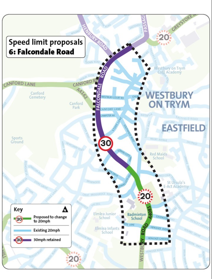
This area focuses on Falcondale Road, in Westbury-on-Trym in north Bristol.
It is a place where people live and has local schools nearby, such as Redmaids' School, St Ursula's Academy, Badminton School, and Westbury-on-Trym Primary School.
Proposed roads to change to 20mph
- Westbury Road
- A short section of Falcondale Road, from Downs Cote Park to Westbury Road
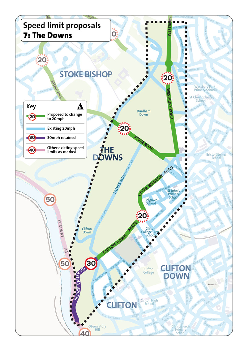
This area includes Durdham Down and Clifton Down near Clifton. It is mostly open green spaces with homes around it.
Proposed roads to change to 20mph
- Clifton Down and Upper Belgrave Road (from Ladies Mile to Stoke Road)
- Stoke Road
- Westbury Road
- Roman Road
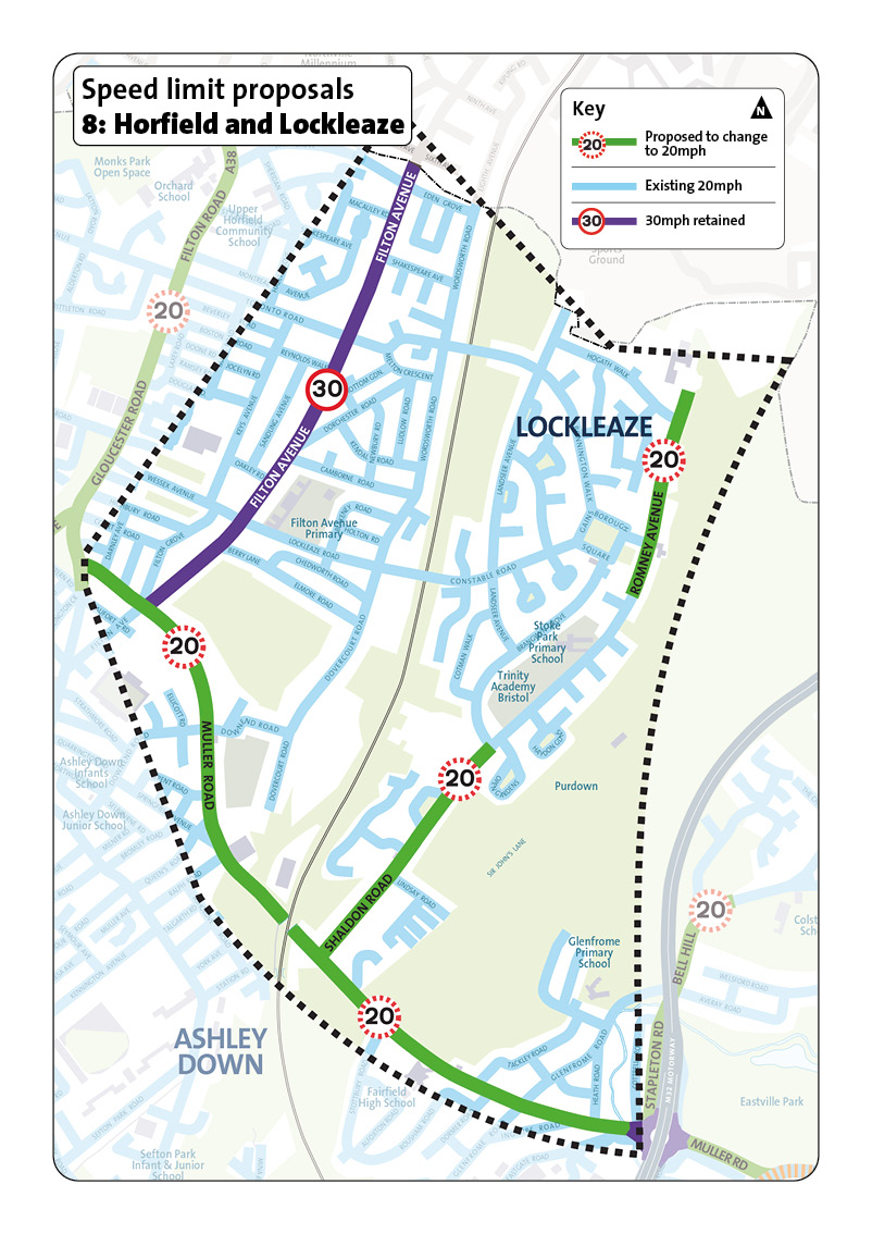
This area includes Lockleaze in north Bristol, along with nearby parts of Ashley Down.
It has local schools such as Stoke Park Primary School, Filton Avenue Primary and Trinity Academy, and includes Purdown and Stoke Park Estate.
Proposed roads to change to 20mph
- Muller Road
- Shaldon Road
- Romney Avenue
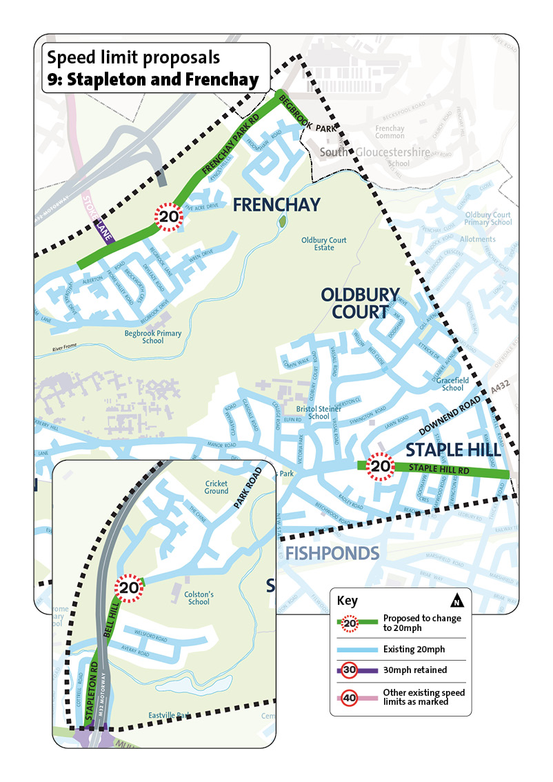
This area includes Staple Hill and Frenchay in north-east Bristol.
It is a place where people live and has local schools such as Begbrook Primary School and Colston's School. Oldbury Court Estate, a large green space, runs through the area.
It borders South Gloucestershire to the north and east.
Proposed roads to change to 20mph
- Stapleton Road and Bell Hill
- Staple Hill Road
- Frenchay Park Road
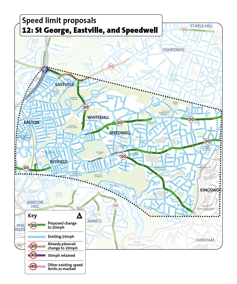
This area includes St George, Easton, Eastville, Troopers Hill, Speedwell, and Two Mile Hill in east Bristol.
It is a place where people live and has several local schools, including Brunel Academy, Oasis Academy John Williams, St Patrick's Catholic Primary School and St Joseph's Catholic Primary School.
The area also includes open spaces such as St George Park, Greenbank Cemetery and Avon View Cemetery.
Church Road is an important high street running through the southern part of the area.
Proposed roads to change to 20mph
- Muller Road
- Royate Hill, Rose Green Road and Gordon Road
- Whitehall Road, Speedwell Road and Ingleside Road
- Clouds Hill, Bell Hill and Two Mile Hill Road
- Summerhill Road, Air Balloon Road, Nags Head Hill and Bryants Hill
- Church Road, Lawrence Hill (Russell Town Avenue to Croydon Street)
Other projects
The existing 30mph section of Fishponds Road is already planned for 20mph as part of the Fishponds Road (A432) Safer Road project.
We'll coordinate delivery of the new speed limits.
This area includes Old Market and Temple Meads.
There are main roads around the city centre such as Bond Street and Temple Way.
It is a busy mixed-use area with major transport hubs, local schools, green spaces, city centre shopping, and Bristol Temple Meads Station.
Old Market is an important local centre and high street.
Proposed roads to change to 20mph
- Old Market, including Old Market Street, West Street, Lawford Street, Lamb Street, Lawfords Gate, Trinity Road, and Old Market Roundabout
- Bond Street and Bond Street South
- Temple Gate and Bath Bridges
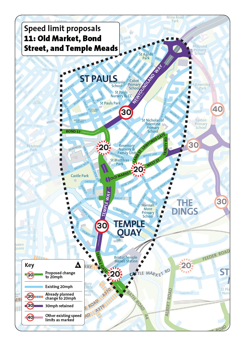
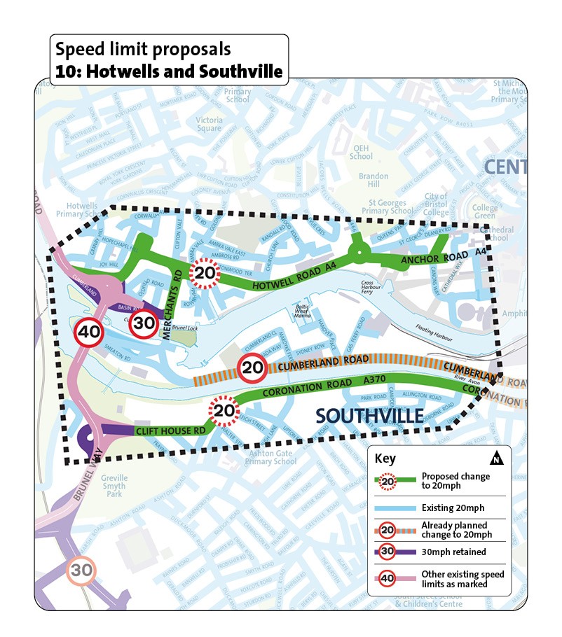
This area includes Hotwells and Southville in central Bristol.
It is a mixed area with homes, local shops and schools, as well as busy main roads and visitor destinations on the waterfront.
Proposed roads to change to 20mph
- Coronation Road and Clift House Road
- Anchor Road
- Hotwell Road
- Merchants Road
- Dowry Square
Other projects
Cumberland Road and the eastern section of Coronation Road are planned for 20mph separately as part of the Bedminster Bridges project.
We'll co-ordinate delivery of the new speed limits.
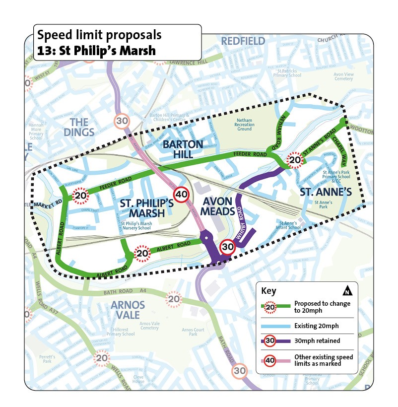
This area includes St Philip's Marsh in east Bristol and the nearby neighbourhoods of Barton Hill, Avon Meads and St Anne's.
It has industrial and commercial sites, retail areas and depots, and some housing.
Proposed roads to change to 20mph
- Feeder Road
- St Anne's Road
- Chapel Way
- Netham Way
- Albert Road and Avon Street
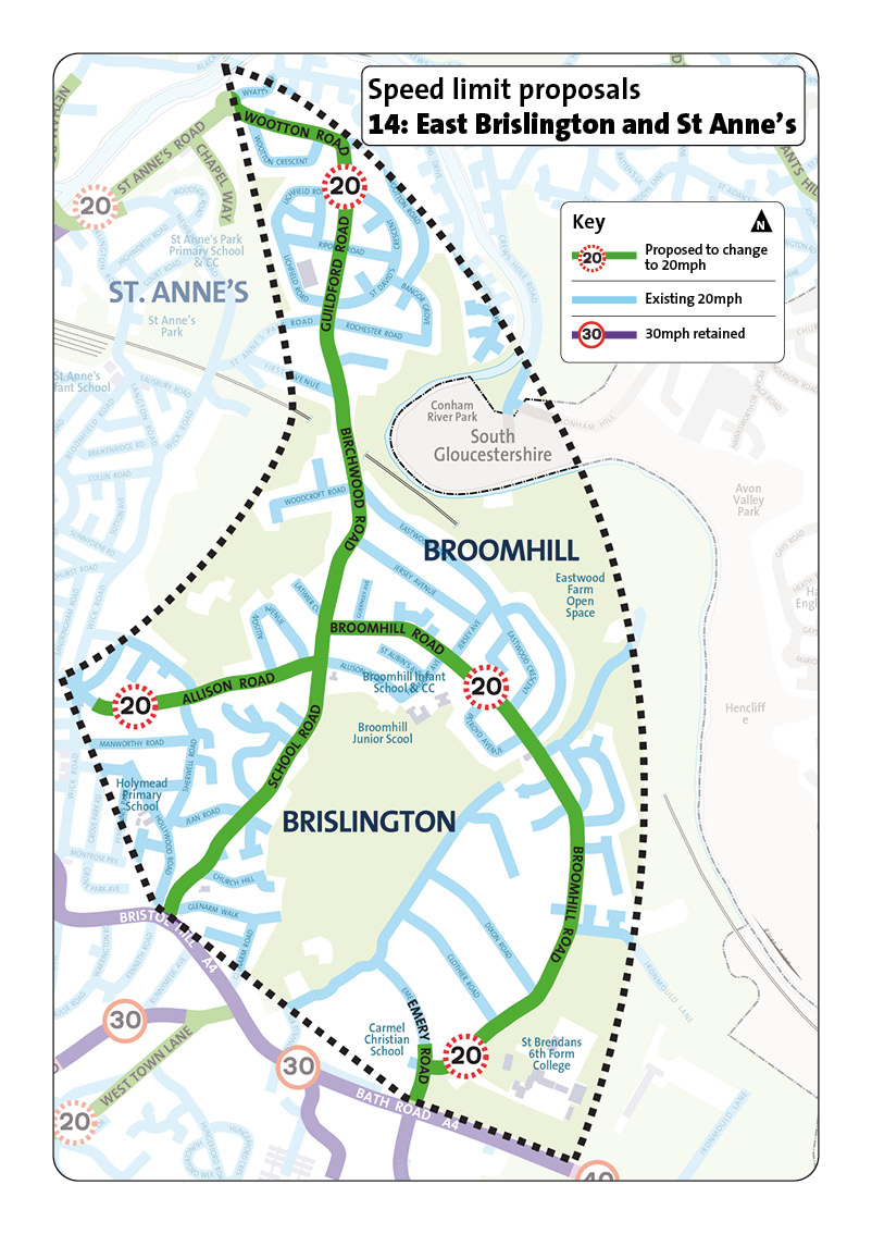
This area includes East Brislington, Broomhill and St Anne's in east Bristol.
It is mainly a place where people live with local schools and green spaces, including Broomhill Junior School, St Brendan's Sixth Form College and Eastwood Farm open space.
Proposed roads to change to 20mph
- Wootton Road, Guildford Road, Birchwood Road, School Road, and Church Hill
- Allison Road
- Broomhill Road
- Emery Road
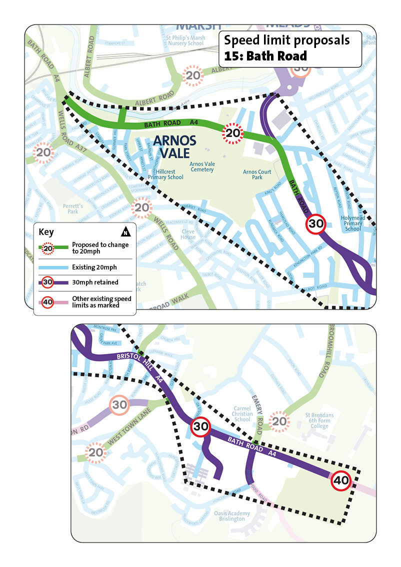
This area focuses on Bath Road (A4) in south-east Bristol which passes through Arnos Vale and into Brislington.
Proposed roads to change to 20mph
Bath Road, from Bath Bridges to near the junction with King's Road.
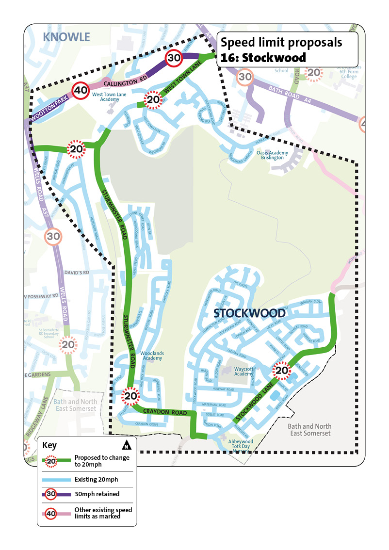
This area includes Stockwood in south‑east Bristol, with links towards Brislington and Hengrove.
It is mainly a place where people live with green spaces and local schools, including Waycroft Academy, Woodlands Academy, Oasis Academy Brislington and West Town Lane Academy.
Proposed roads to change to 20mph
- West Town Lane, Sturminster Road, and Craydon Road
- Stockwood Lane
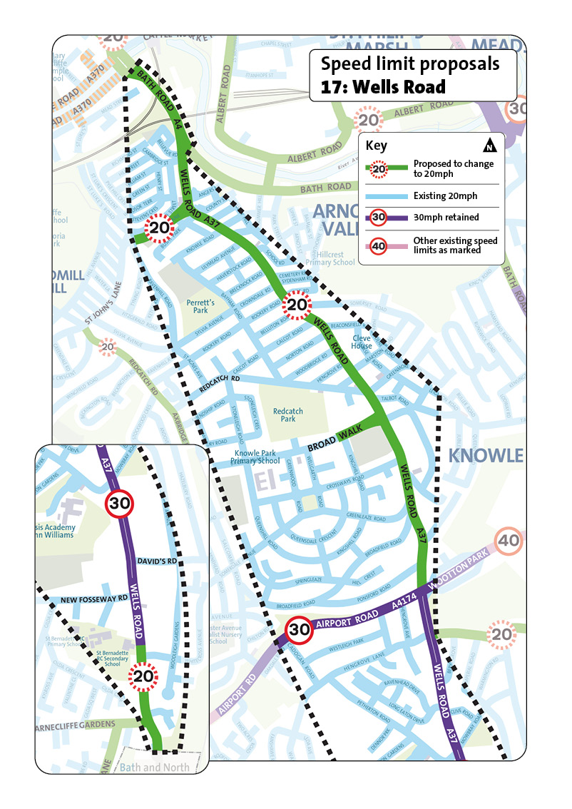
This area covers Wells Road (A37) in south Bristol, from Three Lamps down to Whitchurch. It's a busy route with buses, shops and homes on the side streets.
Nearby places include Redcatch Park and Knowle Park Primary School.
Proposed roads to change to 20mph
- Wells Road, from Three Lamps to Airport Road
- Wells Road, from Whitecross Avenue to Whitchurch
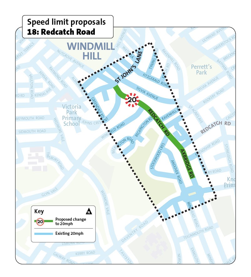
This area focuses on Redcatch Road in south Bristol, running between St John's Lane and Broad Walk. It is mainly a residential route close to Victoria Park and Perrett's Park, with local shops and schools nearby.
Proposed roads to change to 20mph
Redcatch Road and Axbridge Road
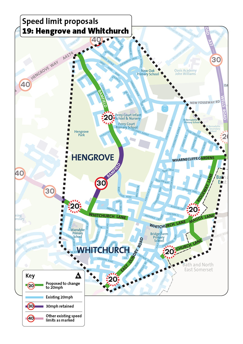
This area includes Hengrove and Whitchurch in south Bristol.
It is mainly a place where people live. It has local schools and community facilities around Hengrove Park and Whitchurch centre.
Key roads include Whitchurch Lane, Bamfield and Ridgeway Lane.
Proposed roads to change to 20mph
- Church Lane, Washing Pound Lane, and Maggs Lane
- Ridgeway Lane and Whitchurch Lane (from Wells Road to Longway Avenue), including a section of Wharncliffe Gardens
- East Dundry Road
- Bamfield from Tarnock Avenue to near Pinkhams Twist
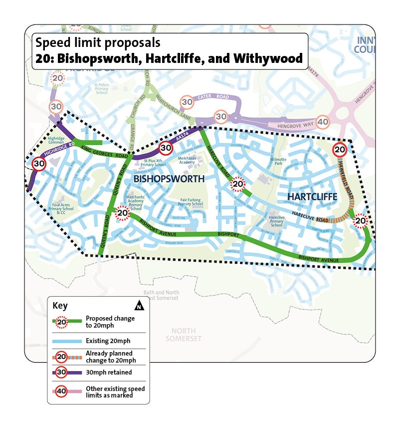
This area includes Bishopsworth, Hartcliffe and Withywood in south Bristol.
It is mainly a place where people live with local centres, green spaces and schools, including Fair Furlong Primary, Hareclive E-Act Academy, and Venturers' Academy.
Proposed roads to change to 20mph
- Bishport Avenue and Broad Oak Road
- Queen's Road
- Hareclive Road, from Whitland Road to current 20mph limit
- Highridge Road
- King Georges Road, from Queen's Road to Highridge Road
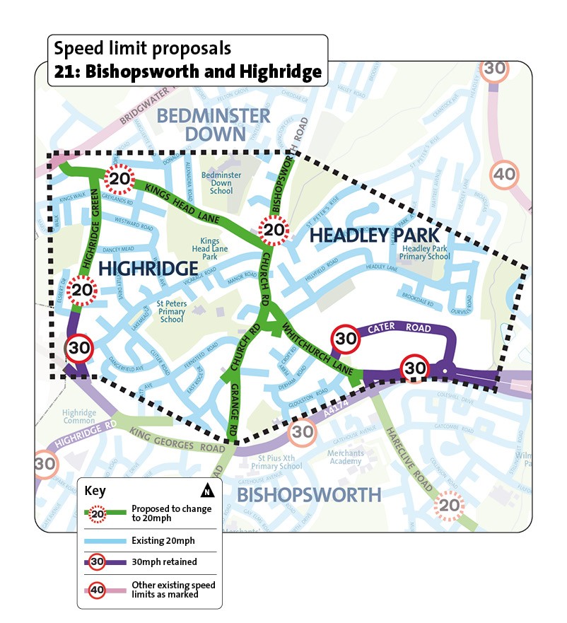
This area includes Bishopsworth and Highridge in south Bristol.
It is mainly a place where people live with green spaces and local schools, including Headley Park Primary School, St Peter's Primary School, Bedminster Down School, and Cheddar Grove Primary School.
Proposed roads to change to 20mph
- Grange Road, Church Road, Whitchurch Lane and Bishopsworth Road
- Kings Head Lane
- Highridge Green
This area includes Bedminster Down and the Parson Street area in south Bristol.
It is mainly a place where people live with local shops and schools, including Luckwell Primary School, Parson Street Primary School and Cheddar Grove Primary School.
The railway line runs through the area, stopping at Parson Street railway station.
Proposed roads to change to 20mph
- Bishopsworth Road, from Banwell Close to Bedminster Down Road
- Parson Street, Bedminster Road, and Bedminster Down Road
- Winterstoke Road, from Bedminster Down Road to Ashton Works